Geoscience Reference
In-Depth Information
(b)
(c)
(a)
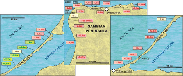
Fig. 16.4
Rate of shoreline shift in 2000-2007 according to monitoring of the ABIO RAS
coasts, both seaward and lagoon, are actively eroded. The most considerable impact
on the unique landscapes of the Curonian Spit National Park, as well as on the
freshwater environment of the Curonian Lagoon, is made by a spit breakthrough
during extreme storm events. The Curonian Spit is known to have “weak points”
where storm waves can break through the sand body. Between 1988 and 1996, its
marine coast was threatened six times by extreme storms. During these storm events,
the shoreline retreated 8-10 m along the distal part of the spit and 2-3 m close to the
town of Lesnoy. In 1983, as a result of a storm event, the spit was broken through
16.4.2.2 Sea Bottom Erosion
Coastal erosion is mainly caused by processes taking place at the sea bottom. The
coastal slope at the Sambian Peninsula and the attached end of the Curonian Spit
from Roshchino to Zelenogradsk is characterized by complicated sediment distri-
butions. The nearshore zone along the Sambian Peninsula is a boulder bench; the
amount of sand material is therefore very limited. It causes an urgent sediment
deficit (“sediment starvation” effect). Areas of coarse-grained sediments (boulders
and cobbles) mark outcrops of glacial till (lag deposits) and indicate active ero-
sion processes, a sediment deficit, and low rates of tectonic subsidence. The areas
of high rates of sediment removal are located mainly deeper than 10 m below sea
level except for the coastal zone adjoining the Cape Taran and in the vicinity of
Zelenogradsk where such areas are locally observed in immediate proximity to the
coast, in a water depth less than 5 m. In areas of the coastal slope of the middle
part of the Curonian Spit, elongated fields of drifting sands with ripple marks are
and their relative depth is 20-60 cm, it can be assumed that they serve as rivulets
of water backwash and sediment outflow after storms or water run-up events. The