Geoscience Reference
In-Depth Information
65°
70°
75°
80°
85°
90°
95°
100°
105°
110°
115°
120°
125°
130°
135°
140°
145°
45°
45°
40°
40°
35°
35°
30°
30°
25°
110°
115°
120°
20°
20°
20°
15°
15°
10°
10°
5°
15°
5°
90°
95°
100°
105°
110°
115°
120°
125°
110°
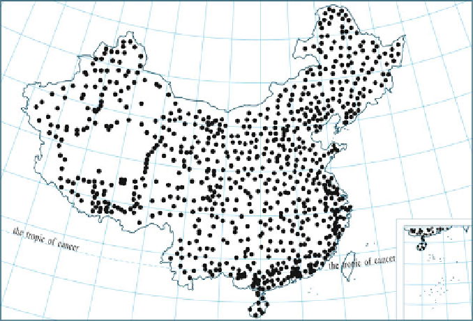
Fig. 3.24 The A-order and B-order national GPS networks
Staff Headquarters (SMBGSH) established high-precision GPS networks, includ-
ing first- and second-order networks, which are called the first- and second-order
nationwide GPS networks. Their scale and accuracy are about the same as that of A-
and B-order national GPS networks. The distribution of their points is shown in
Fig.
3.25
. The complete networks consist of 553 points evenly distributed through-
out China's mainland (except for Taiwan province) and in China's sea areas
including the major reefs of Nansha Islands. The first-order network has 44 points
with an average side length of 680 km and the observations were carried out
between May 1991 and April 1992. The second-order network is divided into six
survey areas (reefs in the South China Sea, Northeast, Northwest, and Southeast
survey areas, North and East China survey areas, and the survey area of Qinghai-
Tibet, Yunnan, Guizhou, and Sichuan) and the observations were carried out from
1992 to 1997. The second-order network is distributed on the basis of the first-order
network with an average side length of 165 km. The points of both the first- and
second-order networks are under leveling connection survey and are made to
coincide with the national astro-geodetic network points. After adjustment compu-
tations, the accuracy of the first-order network is about 3
10
8
, and that of the
10
7
. The coordinate framework adopted in the
adjustment of the A- and B-order networks is ITRF96 at the epoch of 1997.0.
second-order network is about 1
Search WWH ::

Custom Search