Geoscience Reference
In-Depth Information
65°
70°
75°
80°
85°
90°
95°
100°
105°
110°
115°
120°
125°
130°
135°
140°
145°
45°
45°
40°
40°
35°
35°
30°
30°
25°
110°
115°
120°
20°
20°
20°
15°
15°
10°
10°
5°
15°
5°
90°
95°
100°
105°
110°
115°
120°
125°
110°
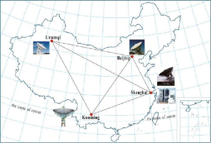
Fig. 3.23 Chinese VLBI network
average side length of about 650 km. In 1996, the repetition measurement of the
A-order network was carried out by the SBSM. After overall adjustment of the
entire network, the geocentric coordinate accuracy is better than 0.1 m, and the
relative accuracy between points is better than 2
10
8
in the horizontal direction
10
8
in the vertical direction.
The B-order network was distributed by the SBSM between 1991 and 1995. The
number of points, together with those of the A-order network, adds up to 818. It is a
continuous network with points of higher density in the east, a combination of a
continuous network and a closed loop with points of moderate density in the center,
and a closed loop and traverse lines with points of lower density in the west. Of all
the points of the B-order network, 60 % coincide with China's first- and second-
order benchmarks while the rest are under leveling connection. The repeatability
accuracy between points of the B-order network is better than 4
and better than 7
10
7
in the
10
7
in the vertical direction. The distri-
bution of A- and B-order national GPS network stations is shown in Fig.
3.24
. The
coordinate framework adopted in the adjustment of A- and B-order networks is
ITRF93 at the epoch of 1996.365.
horizontal direction and better than 8
First- and Second-Order Nationwide GPS Networks
To meet the requirements of military surveying and mapping and national con-
struction, from 1991 to 1997, PLA Surveying and Mapping Bureau of the General
Search WWH ::

Custom Search