Geoscience Reference
In-Depth Information
Walker circulation show up in all five time series at both
regional and localized levels. The reverse conditions
apply during ENSO events, except for the frequency of
tropical cyclones in the Australian region; historically
this is not well correlated to ENSO events. This is owing
to the fact that many cyclones are still counted within
the Australian region even though they have shifted
eastward during these events. More importantly, the
Southern Oscillation appears to switch months in
advance of the arrival of the meteorological conditions
driving these responses. For instance, the heavy rainfall
in eastern Australia, beginning in the autumn of 1987,
was predicted 12 months in advance. Unfortunately,
while the timing of rain can be forecast, its precise
location or the amounts that may fall remain unpre-
dictable because of the spatial variability of precipitation
along the coast. Even during the worst of droughts,
some areas of eastern Australia received normal rainfall.
Links to other hazards are also appearing globally
as researchers rapidly investigate teleconnections
between hazards and the Southern Oscillation. For
example, droughts are often followed by extensive fires
in Florida, eastern Russia, and Indonesia. There is
also heavier precipitation, mainly falling as snow in
north-eastern United States and south-eastern Canada.
The 1997-1998 ENSO event produced five days of
freezing rain
in this region that downed 120 000 km
of power and telephone lines, paralyzing the city of
Montreal. The duration and incidence of tropical
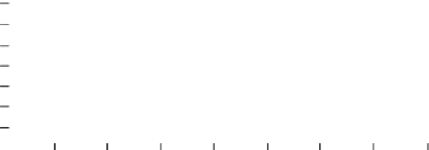
cyclones in the equatorial Atlantic is profoundly
depressed during ENSO years (Figure 2.12). Here,
upper tropospheric winds between 0° and 15°N must
be easterly, while those between 20° and 30°N must be
westerly, before easterly wave depressions and distur-
bances develop into tropical cyclones (hurricanes).
During ENSO events, upper westerlies tend to
dominate over the Caribbean and the western tropical
Atlantic, giving conditions that suppress cyclone
formation. Years leading up to an ENSO event have
tended to produce the lowest number of tropical
cyclone days in the Atlantic over the past century.
Additionally, since 1955, the number of icebergs
passing south of 48°N has been highly correlated to
the occurrence of ENSO events. ENSO events occur
concomitantly with a strengthened Icelandic Low that
results in stronger winds along the North American
east coast. This exacerbates the production and south-
ward movement of icebergs. Both the 1972-1973 and
1982-1983 ENSO events produced over 1500 icebergs
south of 48°N, a number that dramatically contrasts
with non-ENSO years when fewer than one hundred
icebergs per year were recorded this far south. Early
detection of the onset of ENSO events can thus
provide advance warning not only of drought and
rainfall over a significantly large part of the globe, but
also of the occurrence of numerous other associated
hazards.
Oth
er Oscillation phenomena
(Trenberth & Hurrell, 1994; Hurrell, 1995; Villwock, 1998;
Stephenson, 1999; Boberg & Lundstedt, 2002; Hurrell et al.,
2002)
North Atlantic Oscillation
There are two other regions: the north Atlantic and
Pacific Oceans where pressure oscillates on the same
60
40
20
1900
1920
1940
1960
1980
2000
- ENSO year
Number of hurricane days in the North Atlantic-Caribbean Sea region, 1900-2003 (based on Gray, 1984; Hurricane Research Division, 2003).
Fig. 2.12