Geoscience Reference
In-Depth Information
Abnormal rain
Drought
Australian rainfall
SOUTHERN OSCILLATION INDEX
Major bush fires in
Southeast Australia
4.0
2.0
0.0
-2.0
Strong ENSO
Moderate ENSO
-4.0
1840
1860
1880
1900
1920
1940
1960
1980
Number of tropical cyclones
20
10
Discharge - Campaspe River, Victoria
750
500
250
Beach change - Stanwell Park, NSW
-20
-10
0
10
20
Erosion -
Accretion +
Rainfall at Helensburgh, NSW
3.0
2.0
1.0
0.0
Landslip at Kiama, NSW
High
Moderate
Low
1840
1860
1880
1900
1920
1940
1960
1980
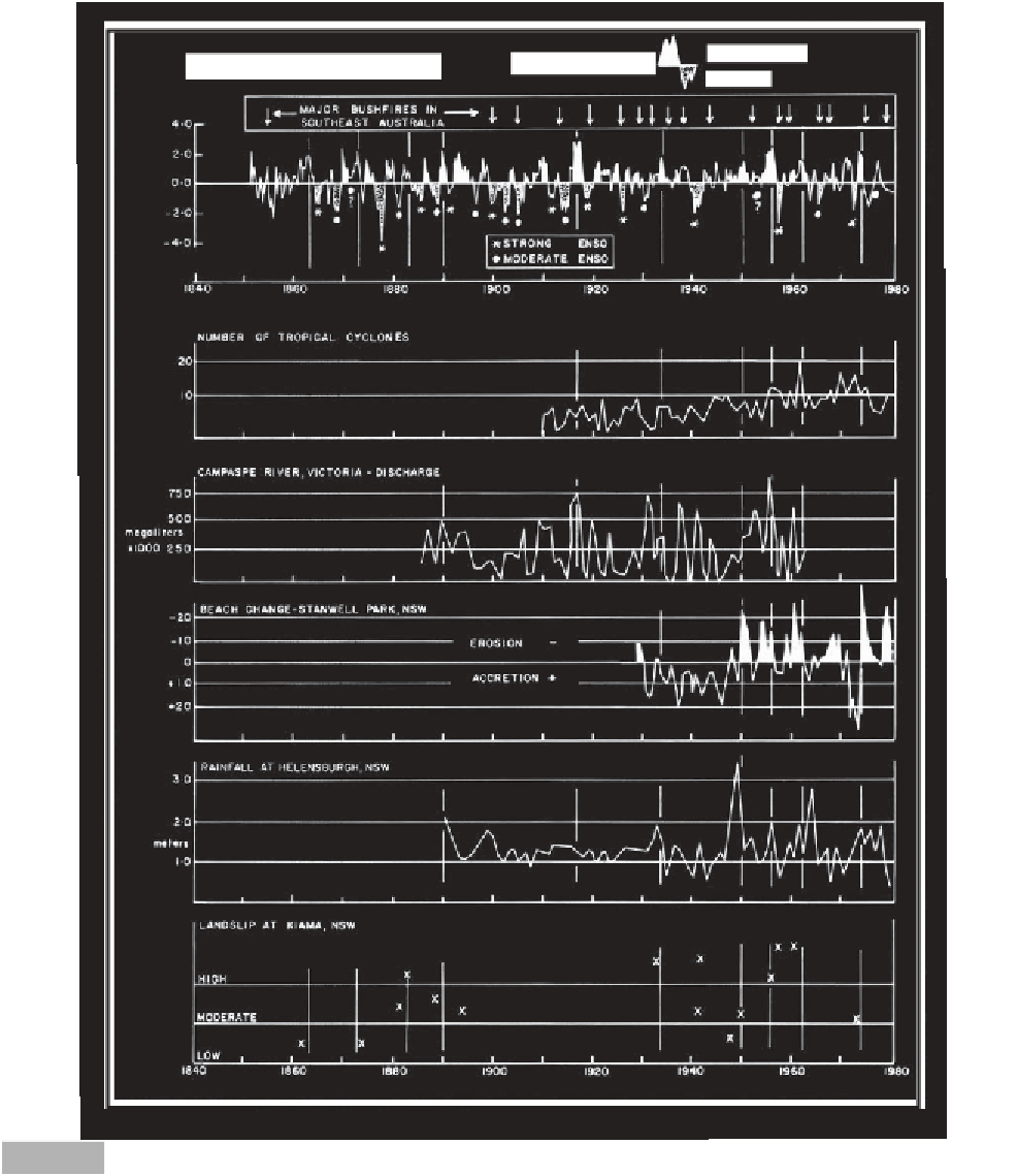
Time series of the Southern Oscillation index, major bushfires (from Luke & McArthur, 1978), Australian cyclone frequency (from Lourensz,
1981), Campaspe River discharge (from Reichl, 1976), beach change at Stanwell Park (from Bryant, 1985), rainfall near Sydney, and
landslip incidence at Kiama (courtesy Jane Cook, School of Education, University of Wollongong).
Fig. 2.11
incidence of landslip in the Kiama area, south of Sydney,
between 1864 and 1978. Drawn on the diagram are lines
passing through all data at the times when the Southern
Oscillation was strongly 'turned on'. At this time, tropical
cyclones were more frequent, the Campaspe River
discharge high, Sydney rainfall heavy, beach erosion at
Stanwell Park more severe, and Kiama landslip more
frequent. The diagram indicates that 'turned on' Walker
circulation results in this predictable geomorphic
response. The 1933, 1951 and 1961 periods of strong