Geoscience Reference
In-Depth Information
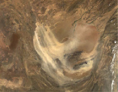
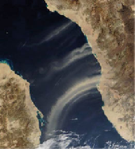
a
c
b
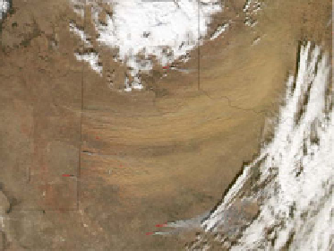
d
Fig. 3.3
(
a
) MODIS image from the Terra satellite showing dust originating from the Bodélé
Depression of the Chad Basin, 11 April 2007.
Dashed line
indicates the approximate extent of
former Lake Mega-Chad (Ghienne et al.
2002
) (Image courtesy of the NASA MODIS Rapid
Response Team, Goddard Space Flight Center). (
b
) MODIS image from the Terra satellite acquired
on 15 January 2009 showing dust plumes from Saudi Arabia moving over the Red Sea in the
direction of Sudan (Image courtesy of MODIS Rapid Response, NASA Goddard Space Flight
Center). Geologic features from Brown et al. (
1989
). (
c
) MODIS image from the Terra satellite
acquired on 20 August 2003, showing dust from the Hamun dry lakes of Afghanistan and Iran
(Image courtesy of Jacques Descloitres, MODIS Land Rapid Response Team, NASA Goddard
Space Flight Center). (
d
) MODIS image from the Aqua satellite acquired on 1 January 2006
showing dust plumes originating in the panhandle of Texas and moving eastward; also shown is the
extent of the Blackwater Draw Formation of Quaternary age, thought to be the source of much of
the dust (MODIS image courtesy of Jesse Allen, NASA Earth Observatory and the MODIS Rapid
Response Team; extent of the Blackwater Draw Formation taken from Texas Bureau of Economic
Geology (
1992
))
watercourses and lakes were widespread (Drake et al.
2011
). A prominent example
is Lake Chad, which today occupies a small area of the central part of the Sahara
Desert, straddling the boundaries of Chad, Nigeria, and Niger. However, in the
early-to-mid Holocene, Paleolake Chad (Fig.
3.3
a) was a much larger water body


Search WWH ::

Custom Search