Geoscience Reference
In-Depth Information
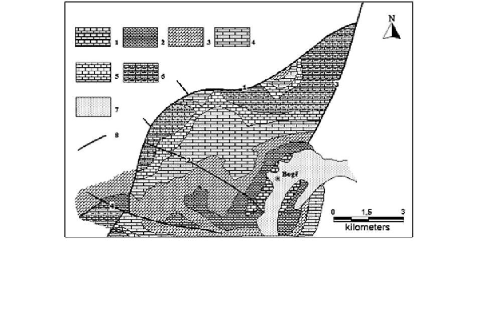
Fig. 2.25
Geological scheme of the investigated territory NW
of the Böge settlement (North Albania), carried out on the base of
Geological Map of Albania in scale 1:200 000 (1981) (Shanov
1999
—Reproduced by permission of Geologica Balcanica)
1—Upper Triassic limestones and dolomites; 2—Lower Jurassic
limestones and dolomites; 3—Middle-Upper Jurassic undivided
limestones and dolomites; 4—Upper Jurassic limestones and
clayey sands; 5—Tithonian limestones; 6—Lower Cretaceous
limestones, carbonate limestones, clayey sands; 7—Quaternary
sediments in superimposed depressions; 8—faults: 1—Pjetro-
shan-Velicikut-Kozhnje;
2—Dobromiri;
3—Böge—Budace;
4—Rapsh-Boçani
karst system could practically exist. The conditions
for vertical channels precipices are much better.
Several expeditions of the Bulgarian Speleological
Federation just prove the mass development of prec-
ipices reaching depths from tens to 500 m (Fig.
2.27
).
The speleological as well as the geological struc-
tural investigations in the karstic massif to the
northwest of Böge settlement (Fig.
2.23
) clarified
additionally some problems and showed a strong
significance of the fault tectonics as a factor for
precipices and caverns formation in the most frag-
mented by young displacements zones.
The measurements of the space elements of joint
systems and tectonic striations on different surfaces of
outcrops have been carried out only at 16 points
(Fig.
2.28
) because of relief complexity, its difficult
access and the limited time for field observations. The
information turned to be sufficient for reconstruction
of the main tectonic deformation phases after Early
Jurassic times up to present days, which determine the
main relief characteristics as well as the superficial
and underground karst features.
2.3.1.3 Investigation Methods
Three basic methods were used for reconstruction of
the principal axes of the tectonic stress field. Detailed
analysis of the final results from each observation
point allowed to distinguish the different deformation
phases imprinted in the structure of the joint systems
of the karstic massif and controlling the basic char-
acteristics of the karstic processes and to determine
their age.
Fault-Plane Solutions from Earthquakes
Only one fault-plane solution was available for the
purposes of the investigation, i.e., an earthquake with
magnitude M = 5.1 (f November 3, 1968) and epi-
center localized to the southwest of the studied region
(N 42.10, E 19.35). The data are taken from the
paper of Muço (
1994
).
Tectonic Stress Field Reconstruction
from Striations on Slickensides
These investigations occupy the most significant place
in the collected information because, in 11 points of