Geoscience Reference
In-Depth Information
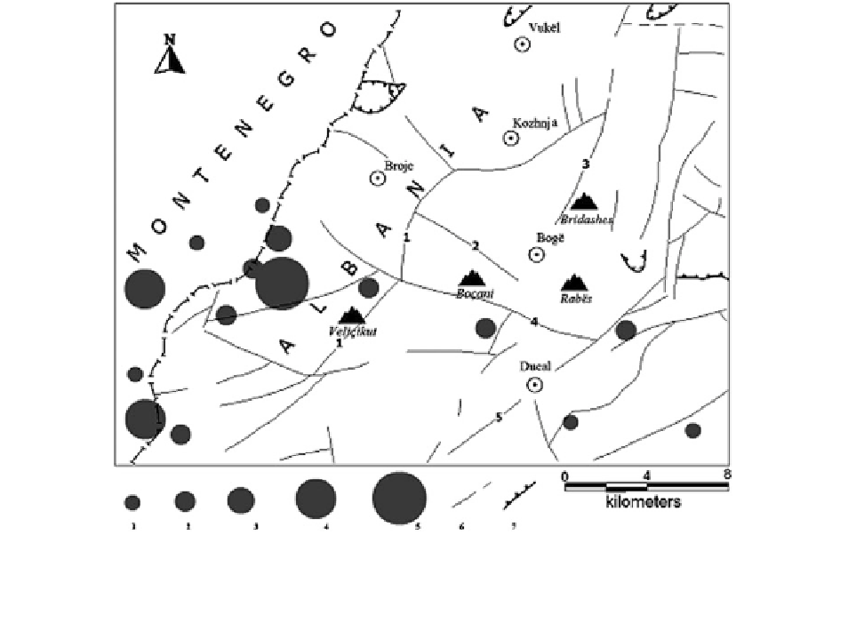
Fig. 2.24
Main fault structures and epicenters of recorded
earthquakes for the period 1961-1988 in the studied area
(Shanov
1999
—Reproduced by permission of Geologica Bal-
canica) Earthquake magnitudes: 1—M \ 2.0; 2—M = 2.1-3.0;
3—M = 3.1-4.0; 4—M = 4.1-5.0; 5—M = 5.1-6.0; Faults:
6—normal faults; 7—thrusts; More important regional faults:
Pjetroshan-Veliçikut-Kozhnje; 2—Dobromiri; 3—Böge- Bud-
ace; 4—Rapsh-Boçani; 5—Ducal
following tectonic events during the Alpine tectono-
genetic phases and especially the intense overthru-
sting of a part of the limestones complex to the South
increased
line Pjetroshan-Velicikut-Kozhnje plays the role of
main distributor of underground water outflow in the
region localized west-northwest of Böge settlement.
There are concentrations of karstic springs along the
northwestern fault wall. Probably, an enormous
underground water flow is drained by the same fault,
coming out on the surface near the village of Pjetro-
shan by a well-developed karst spring system. One of
the springs has a discharge up to 4 m
3
/s.
At the same time, the southeastern fault wall,
constituted by faulted blocks, offers all conditions
needed for draining of huge superficial water quanti-
ties (most of all atmospheric) and their running
toward the drainage zone. The investigated region is
localized in joints-karstic type of water-bearing sys-
tem having an effective infiltration ratio about
0.6-0.7. In these conditions, the atmospheric waters
penetrate fast in the water-bearing system and flow
toward their natural drainage level. In this way, no
conditions stimulating the development of horizontal
the
thickness
of
the
rock
complex
(Fig.
2.26
).
The neotectonic uplift and denudation led to the
contemporary complex relief, with altitudes exceed-
ing 2,000 m. It could be supposed that the thickness
of the carbonate rocks, now subjected to karstifica-
tion, is more than 1,500 m. An argument for this
supposition is the concentration of important karstic
springs at altitude of some tens of meters over sea
level and running out of impressive quantities of fresh
water in Shkodra Lake and Adriatic Sea. The tectonic
factor should be also taken into account—fault sets
that facilitate the drainage of superficial water outflow
by channels, which do not allow always the formation
of accessible karstic cavities.
According to the Hydrogeological Map of PSR of
Albania M 1:200 000 (
1981
), the fault marked by the