Geoscience Reference
In-Depth Information
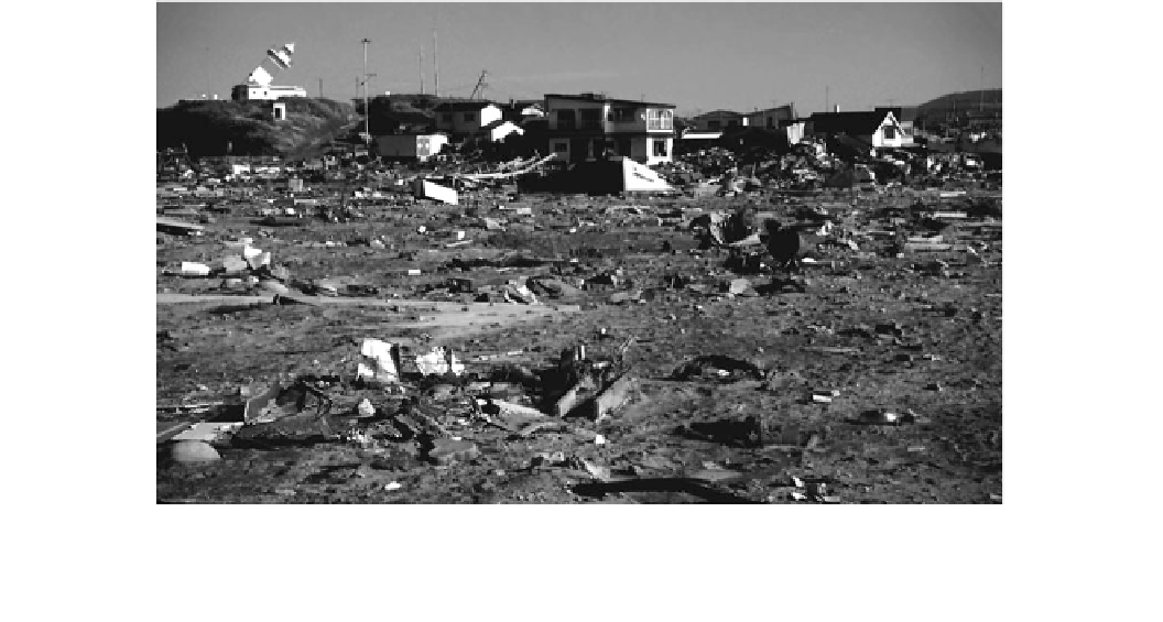
Fig. 5.10
Damage at Aonae, Okushiri Island, due to the Hokkaido
Nansei-Oki Tsunami of July 12, 1993. The earthquake, and not the
tsunami, damaged the leaning lighthouse. Concrete foundations in the
foreground have been wiped clear of shops, houses, and kiosks. Note
the gravel and boulder dump deposit, and the similarity of the unit to
J. Sigrist, International Tsunami Information Center at Honolulu,
Hawaii. Source National Geophysical Data Center
walls have been constructed in and around Tokyo and other
metropolitan areas of Japan to protect urban areas from
tsunami. They have proven just as ineffective, especially
following the T ¯hoku Tsunami of 2011. In the town of
Aonae, at the extreme southern tip of Okushiri Island, the
first wave arrived from the west with a height of 7-10 m,
overtopping the protective barriers and destroying the
exposed southern section of the town (Fig.
5.10
). About
10-15 min later a second tsunami struck the sheltered,
unprotected, eastern section of the town from the east,
igniting fires that burnt most of the remaining buildings
(Shuto and Matsutomi
1995
). The possibility that the sec-
ond wave originated from aftershocks cannot be ruled out.
The tsunami washed away half of the 690 houses in the
town, although most were bolted to concrete foundations
(Shimamoto et al.
1995
). The tsunami also severely dam-
aged port facilities, power lines, and roads, stripping away
pavement and depositing it inland (Murata et al.
2010
). At
Hamatsumae, which lies in the sheltered southeast corner of
the island, run-up measured 20 m above sea level. This high
run-up was most likely due to refraction of a trapped soliton
around the island—an effect similar to that produced around
Babi Island during the Flores Tsunami (Yeh et al.
1994
).
Within 5 min of the earthquake, the tsunami also struck
the west coast of Hokkaido with a maximum run-up of 7 m
elevation (Shuto and Matsutomi
1995
). The simultaneous
arrival times along Hokkaido and Okushiri Islands suggests
that there may have been another tsunamigenic mechanism
involved
southwards, it reached a height of 3.5 m at Minehama.
50-70 min after the earthquake, the tsunami reached the
coastline on the opposite side of the Sea of Japan, striking
the Russian coast with an average run-up of 2-4 m elevation
(Oh and Rabinovich
1994
). 40 min after this, the wave
reached the South Korean coast at Sokcho and propagated
southward to Pusan over the next 90 min. The tsunami wave
height, as measured on tide gauges, was 0.2 m, 1.8 m, and
2.7 m respectively at Pusan, Sokcho, and Mukho. At Sokcho
and Mukho, where the coastline and continental shelf edge
are smooth and straight, waves were detectable for the next
two days with periods averaging around 10 min. Along the
Pusan coast, dominated by bays and islands, wave periods
were two to three times longer and decayed more slowly. It
appears that tsunami amplification took place along the
central Korean Peninsula, while seiching occurred along the
south coast in bays and harbors. There was also evidence of
resonance effects in the Sea of Japan as a whole.
The tsunami's characteristics were heavily dependent
upon the configuration of the coastline. At some locations
sea level withdrew before the arrival of the tsunami crest,
while at others the crest arrived first. Equal numbers of
localities reported either the first or the second wave as the
biggest. Run-up heights in many locations were two to
three times greater than the initial height of the wave at
shore. Calculations of the force required to remove houses
bolted to concrete slabs indicate that flow velocities
reached maximum values of between 10 and 18 m s
-1
(Shimamoto et al.
1995
). The tsunami deposited 10-cm
thick sandy splays behind sand dunes (Sato et al.
1995
).
in
generating
the
tsunami.
Tsunami
run-up
decreased
on
the
north
coast
of
Honshu;
however,