Geoscience Reference
In-Depth Information
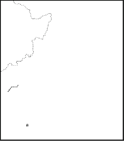
Fig. 5.9
Areas and epicenters of
twentieth century seismic activity
in the Sea of Japan. Based on Oh
and Rabinovich (
1994
). Detailed
map shows location and height of
the Hokkaido Nansei-Oki
Tsunami of July 12, 1993. Based
on Shuto and Matsutomi (
1995
).
Height bars are scaled relative to
each other
125°
130°
135°
140°
145°
50°
Russian
Federation
Hokkaido
Okushiri
Island
1971
M
w
= 6.9
China
45°
1940
M
w
= 7.5
1993
M
w
= 7.8
Aonae
Sea
of
Japan
Hamatsumae
North
Korea
1983
M
w
= 7.7
40°
Sokcho
Mukho
1964
M
w
= 7.5
Minehama
South
Korea
Pacific
Ocean
Honshu
Japan
Pusan
35°
0 0
100 km
(= 5m)
Height of tsunami
1993 Earthquake epicentre
20th century seismic activity
30°
5.4.3
The Hokkaido Nansei-Oki Tsunami of July
12, 1993
263 were drowned. The tsunami also affected the southern
coast of Sulawesi Island where 22 people were killed. Two
hours
after
the
earthquake,
smaller
waves
arrived
at
Ambon-Baguala Bay on Ambon Island.
Along much of the affected coastline, widespread erosion
took place, denoted by coastal retreat, removal of weathered
regolith and soils, and gullying (Shi et al.
1995
). Small cliffs
were often created by soil stripping, probably as the result of
downward eroding vortices within turbulent flow. The tsu-
nami spread a tapering wedge of sediment 1-50 cm in
thickness as much as 500 m from the coast. The wedge
consisted of sand material swept from the beaches and shell
and coral gravels torn up from the fringing reefs. Clay and
silts appear to have been winnowed from the deposits by
preceding tsunami backwash. Grain size tended to decrease,
but sorting increased, towards the surface of these deposits.
This pattern indicates an initial rapid rate of sedimentation.
Grain size also tended to fine inland as the competence of the
flow decreased concomitantly with a decrease in flow
velocity. On Babi Island, there was a coarsening of grain size
at the limit of run-up (Minoura et al.
1997
). Saw-tooth
changes in grain size upwards through the deposits indicate
that more than one wave was responsible for laying down the
sand sheet. Sediment sequences on Babi Island imply that
two different tsunami struck: the first from the direction of
the earthquake and the second as the result of a trapped edge
wave refracting around the island. This second wave was
stronger than the first as shown by the transport of coarser
material including large molluscs. Modeling indicates that
the first wave had a run-up velocity of 1 m s
-1
, while the
second one traveled faster at velocities of 2-3 m s
-1
.
In the late evening at 11:17 PM (13:17 UTC) on July 12,
1993 a strong earthquake with a moment magnitude, M
w
,of
7.8 was widely felt throughout Hokkaido, northern Honshu,
and adjacent islands (Yanev
1993
). The earthquake occur-
red in the Sea of Japan, north of Okushiri Island (Fig.
5.9
).
The Sea of Japan has historically experienced 20 tsunami, 4
of which have occurred in the twentieth century. The 1993
event occurred in a gap between the epicenters of the 1940
and 1983 earthquakes (Fig.
5.9
), and had a focal depth of
about 34 km (Oh and Rabinovich
1994
; Murata et al.
2010
).
This location coincides almost exactly with the epicenter of
the Kampo earthquake of August 29, 1741, which produced
a tsunami with a maximum run-up of 90 m along the
adjacent Japanese coast. Aftershocks from the 1993 event
covered an ellipsoid 150 km long and 50 km wide close to
Okushiri Island. About 150 km of faulting may have been
involved in the event. The earthquake consisted of at least
five intense jolts spaced about 10 s apart (Fig.
5.1
). Two to
five minutes later a tsunami with an average run-up height
of 5 m spread along the coast of Okushiri Island and killed
239 people—many of whom were still trying to flee the
coastal area. On the southwestern corner of the island, run-
up reached a maximum elevation of 31.7 m in a narrow
gully. This was the highest run-up of the twentieth century
in Japan, surpassing that of the deadly Showa Tsunami of
1933 (Shuto and Matsutomi
1995
). Tsunami walls up to
4.5 m high protecting most of the populated areas were
overtopped by the tsunami (Murata et al.
2010
). Similar