Agriculture Reference
In-Depth Information
8
Signature LandformS
In this chapter you will learn about:
The concept of landform signatures and the correlation between landforms found in
nature and the creation of site-grading solutions
•
Landform SignatureS
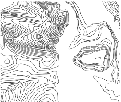
Contours on a topographic map have very specific shapes or forms. Each land-
form has a recognizable arrangement or pattern of contours in plan. Each land-
form has a plan arrangement of contours that is often described as a contour or
landform signature. Four contour signatures can be seen in Figure 8.1. Area A is
a signature for a mound or hill, B is the signature for a valley, C is the signature
for a concave or crown-shaped landform, and the nearly parallel contour lines
of D form the signature of a sloping, uniform plane.
A mound or mountain form is
shown in plan as contours arranged
in concentric or irregular concentric
circles, as shown in the circled area
labeled A in Figure 8.1. A valley land-
scape (area B in Figure 8.1) has its
unique signature with the contours
arranged with a “V” bottom, indicating
a sharp, incised valley shape formed by
the erosive action of a river or drainage
swale. Contours with a wide, flat bot-
tom represent a valley formed by the
B
A
C
D
Figure 8.1
Four distinct landforms found in nature