Environmental Engineering Reference
In-Depth Information
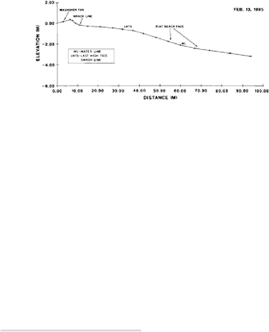
Fig. 5
Typical arcuate delta flanks beach profile plot (Sexton and Murday
1994
)
Holocene environment. Sediments originate from a
drowned coastal plain, while the estuaries are meso-tidal
having a composite delta development with a landward side
(flood-tide delta) and a seaward side (ebb-tide delta) with
salt marshes and tidal flats at the boundaries next to strongly
meandering upstream reaches partially mixed with seasonal
stratification variations. It should be noted that spring tide
currents favor turbulent flow exchanges and a lowering of
the mixing stratification ratio with a less sharp interface.
However, a zone of high salinity gradient is established at
about mid-depth, while the surface and bottom layers are
quite homogeneous (Hume and Herdendorf
1988
; Dyer
1997
; Seminara et al.
2001
; Defra
2002
).
Niger Delta Beach Profile
The Niger Delta flanks (Fig.
4
) consist of very fine-grained,
mica-rich sand with prominent anti-dunes on active beach
faces. These beaches usually have moderate (less than 1 m)
wave heights, and the very wide intertidal beach faces
heights often greater than 175 m with gentle slope profiles
ranging from 1:50 to 1:90. Beaches on the western delta
flank are slightly finer grained and flatter, while the tidal
amplitudes for the eastern delta and western delta flanks are
2.5 and 1.5 m, respectively.
The Niger arcuate delta (Fig.
5
) covers 284 km of
Nigeria's coastline (not including the delta flanks) and is
composed of fine- to medium-grained, well-sorted sand with
barrier island beaches having moderate intertidal beach
faces (50 m) with steeper slopes in relation to the delta
flanks of 1:15-1:20.
Bonny River Estuary
The Bonny river system has the largest tidal volume within
the Niger Delta (NEDECO
1961
), composed of an estuarine
and highly saline seawater located seaward of the river
mouth (typical of the Niger Delta coastal region), and
influenced by tide- and wind-driven surface currents. The
Bonny River estuary lies in the strand coast, between lon-
gitudes 658
0
and 714
0
East, and latitudes 419
0
and 434
0
North. It has an estimated area of 206 km
2
and extends
7 km offshore to a depth of about 7.5 m (Irving
1962
; Scott
1966
). It is a partially mixed estuary with a typical tidal
water zone and little freshwater input but extensive man-
grove swamps and intertidal mud flats, which are being
influenced by the semidiurnal tidal regime. In the Bonny
River estuary, the salinity fluctuates with the season and tide
regime and is influenced by the Atlantic Ocean (Dangana
1985
) with a tidal range of about 0.8 m at neap tides and
2.20 m during spring tides (NEDECO
1961
). The estuary
width is about 3,000 m and narrows down to 200 m
upstream with water depth decreasing upstream except in
the relatively shallow expanse where the Opobo channel
Box 3: Nigerian Coastal Region
• The Niger Delta consists of the western delta flank,
arcuate delta, and eastern flank categories.
• The western side of the delta has significant active
freshwater and sediment delivery, while the eastern
side is influenced primarily by marine processes
(waves and tides).
Niger Delta Estuaries
The Niger Delta estuarine waters cover an area of about
680 km
2
(Fig.
6
). The Bonny/New Calabar river systems
form about 39 % of the total area (Sott 1966). The Niger
Delta area is the richest part of Nigeria in terms of natural
resources with large deposits of petroleum products (oil and
gas) (Braide et al.
2004
). The Niger Delta is a tidal river
estuary of fluvial erosion origin and a fully developed


Search WWH ::

Custom Search