Environmental Engineering Reference
In-Depth Information
the Ecopedological map, were overlayed using the ESRI ARC/GIS software thus
enabling the climate and soil-land-use combinations to be defined. The mean SOC
stock value was consequently calculated for each cropland land use type combi-
nation. An analysis of variance was made (ANOVA), to statistically compare the
SOC stock means, clustered according to the different climate regions, land use
types and landscapes.
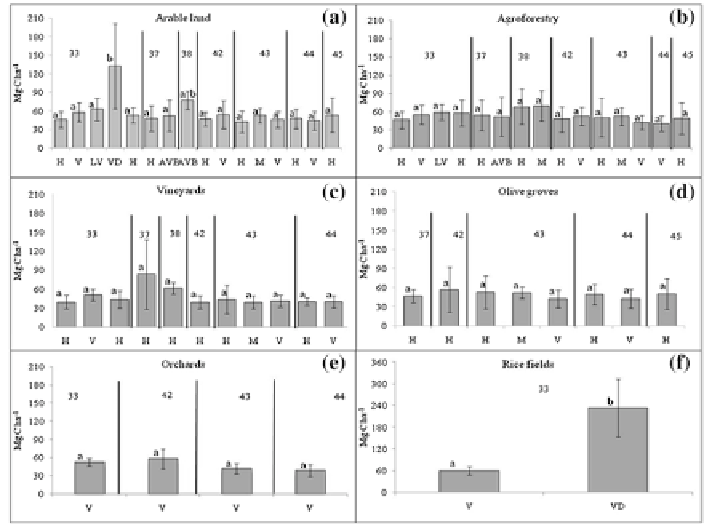
The land use types “arable land” and “agroforestry” are the only being present
in all of the different climatic regions of Italy. The arable land SOC stock does not
show substantial differences between the different climate types with an amount
of SOC comparable to those of the agroforestry subcategory with a SOC stock
varying from 40.1 2.3 Mg C ha
−
1
in the Mediterranean subtropical region to
69.8 25.3 Mg C ha
−
1
in the temperate mountain one (Fig.
8.2
).
Vineyards' SOC stock varies from 39.2 10.0 Mg C ha
−
1
on mountains
relief of the warm Mediterranean sub continental type of climate, to
Fig. 8.2
SOC stock (2000) in the top 30 cm mineral soil of the subcategories Arable land,
Agroforestry, Vineyards, Olive groves, Orchards and Rice fields under the different type
of climates: temperate sub oceanic (
33
), temperate subcontinental to temperate continen-
tal partly mountainous (
37
), warm temperate sub continental (
38
), Mediterranean oceanic
to Mediterranean sub oceanic partly mountainous (
42
), Mediterranean sub continental to
Mediterranean continental (
43
), Mediterranean to sub tropical (
44
), Mediterranean mountainous
(
45
).
H
hills;
V
valley;
LV
low valley;
VD
valley depression;
AV B
alluvial valley bottom;
AV
allu-
vial valley;
M
mountains.
Bars
represent the standard deviation.
Different letters
indicate signifi-
cant difference (
p
< 0.05)