Environmental Engineering Reference
In-Depth Information
fields), according to the different climatic zones and landscapes of the country,
a pedological database derived from different sources was used. A national pro-
ject started in 2007 within the framework of the Multi-Scale Soil Information
System (MEUSIS) European project and denominated “SIAS”, Development
of Soil Indicators in Italy, was the main source of information for the SOC stock
(
http://eusoils.jrc.ec.europa.eu/projects/Meusis/italy.html
)
. The SIAS database
reports the elaborations and the metadata for soil organic C stock in agreement with
the IPCC standards (IPCC
2003
). Following the European Directive denominated
“INfrastructure for SPatial InfoRmation for Europe” (INSPIRE, COM 516/2004),
the SIAS data refers to the INSPIRE grid having cells of 1 by 1 km. The value
for each cell is an average value of the C stock of the upper 30 cm of mineral soil,
weighed on the real surface of the cell covered by soil. For the country areas not
covered by the SIAS project, an INSPIRE grid was created according to the guide-
lines available at the European Soil Bureau website (
http://eusoils.jrc.ec.europa.eu
)
.
The analytical data to calculate the soil carbon stock of the representative profiles
for each INSPIRE cell were obtained from regional reports. The data coverage of
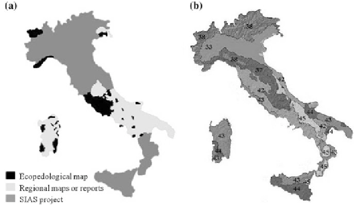
the Italian country are reported in Fig.
8.1
a.
The climatic subdivision of the Italian territory was done following the
“Georeferenced Soil Database for Europe: Manual of Procedures Version 1.1.
Eur 18092 EN” (Finke et al.
1998
). Accordingly, the Italian territory was classi-
fied in seven areas with a different type of climate (Fig.
8.1
b). The CORINE Land
Cover 2000 (Sinanet
2009
), the climatic database, the soil C stock databases and
Fig. 8.1
On the
left side
a
, coverage distribution of the different data sources used in this
study. On the
right side
b
, climatic subdivision of the Italian territory. Letters indicate the dif-
ferent climate types:
33
Temperate sub oceanic,
37
Temperate subcontinental to temper-
ate continental partly mountainous,
38
Warm temperate sub continental,
42
Mediterranean
oceanic to Mediterranean sub oceanic partly mountainous,
43
Mediterranean sub continental to
Mediterranean continental,
44
Mediterranean to sub tropical,
45
Mediterranean mountainous