Geology Reference
In-Depth Information
-
The use of geophysical techniques, such as microgravity surveys,
prior to the formation of the reclamation, would have greatly
assisted the formulation of a realistic geological model, thereby
maximising the potential of the site and reducing costs.
-
Ground investigations in areas of complex ground, deep tropical
weathering and the presence of calcareous metasedimentary rocks,
require advanced drilling techniques and high levels of soil
recovery.
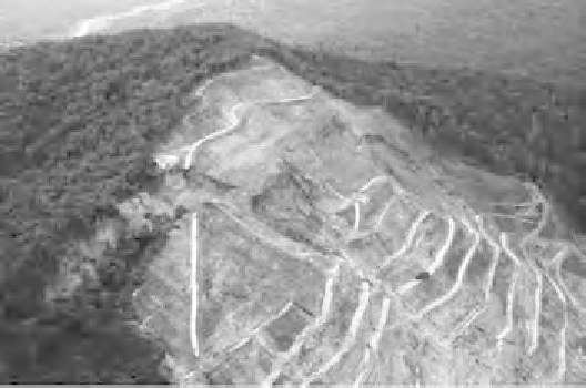
landslide, Malaysia
The Pos Selim landslide in Malaysia is described by Malone
et al
.
(2008). The landslide occurred in one of the many large and steep cut
slopes along the new 35km section of the Simpang Pulai
Lojing
Highway project, and it is pertinent to ask the question why did it
occur there rather than somewhere else?
Failure occurred early on in a small cut slope and affected the natural
slope above the cutting. Progressively, the slope was then cut back in
response to further failures until the works reached the ridgeline about
250m above the road (
Figure 7.13)
. The slope then continued to move
with huge tension cracks developing near the crest, with vertical drop
at the main scarp of more than 20m in three years.
Clearly, at the site there are some predisposing factors that are
causing instability, whereas many other equally steep slopes along
the 35km of new highway show no similar deep-seated failures. The
general geology of the site is schist but the main foliation actually
dips into the slope at about 10 degrees, so the common mode of failure
associated with such metamorphic rocks, of planar sliding on day-
lighting, adverse schistosity, or on shear zones parallel to the schistos-
ity (Deere, 1971), is not an option to explain this landslide. Following
-