Global Positioning System Reference
In-Depth Information
errors. That is, error estimation is not enough at the beginning, and the yaw angle gradually
improves. For that reason, in the case of ordinary GPS/IMU, it is necessary to have the
system alignment before the measurement in order to estimate an accurate azimuth angle.
Therefore, in this proposed method, the system alignment is not required. Figure 9 shows
the roll and the pitch angle of the two methods. The phenomenon of the error for the roll
and pitch angle is the same as the yaw angle.
5. Experiment
In order to appraise the characteristics and performance of the proposed algorithm, two
experiments are conducted by using a UAV (Unmanned Aerial Vehicle) and ground vehicle
(a car) as a platform. In the case of the UAV, images are used for external aid, whereas VMS
is used as an external aid in the case of the ground vehicle.
5.1 UAV (Unmanned Aerial Vehicle) based mapping system
A UAV based mapping system is developed to obtain both the wide-area coverage of
remote sensors and the high levels of detail and accuracy of ground surveying, at low cost.
All the measurement tools are mounted under the UAV, which resembles a helicopter, to
acquire detailed information from low altitudes, unlike high altitude systems in satellites or
airplanes. The survey is conducted from the sky, but the resolution and accuracy are equal
to those of ground surveying. Moreover, the UAV can acquire data easily as well as safely.
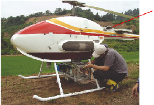
In this paper, all of the measurement tools are mounted under the UAV, which is a
helicopter-like model RPH2 made by Fuji Heavy Industries, Ltd., and shown in Figure 10.
All the sensors are mounted tightly to the bottom of the fuselage. The RPH2 is 4.1m long,
1.3m wide and 1.8m high. Table 4 shows its main specifications.
GPS
(Ashtech G12)
PC
IMU
(Tamagawa Seiki TA7544)
Digital Camera
(Canon EOS-10D)
Laser Scanner
(SICK LMS-291)
Fig. 10. UAV, model RPH2 made by Fuji Heavy Industries, Ltd.
As shown in Table 4, the RPH2 is a large UAV; however, it is considered a platform for the
experimental development of a multi-sensor integration algorithm. The RPH2 has a large
payload capacity; thus, it can carry large numbers of sensors, control PCs, and a large
battery. After the algorithm is developed by a large platform, a small UAV system is
implemented using selected inexpensive sensors for certain observation targets.


Search WWH ::

Custom Search