Environmental Engineering Reference
In-Depth Information
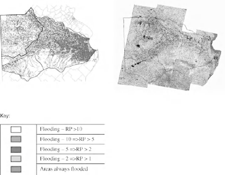
Fig. 22.10
Sample Flood Probability Map (FPM) produced using the regional flood model. RP, return period. (See the
colour version of this figure in Colour Plate section.)
Using MODFLOW alone to generate FPMs
would not, however, be a robust approach as it
can only identify the extent of surface flooding
approximately. This is the case because it fails
correctly to estimate the depths of water ponded
and flowing on the surface. Also, its utility for
mapping the probability of surface flooding is
tightly linked to a number of factors concerning
the schematization of the model. Forcing the res-
olution of the groundwater model to match the
resolution of the micro-relief features helps to
identify more precisely the location of flooded
areas. However, the fact that model outputs
vary with the temporal resolution of the hydro-
logical stresses input to the model (monthly or
daily), represents a significant weakness in this
approach.
The groundwater heads predicted by MOD-
FLOW are strongly influenced by the vertical
components of the water balance, evapotranspira-
tion fromthe saturated zone and, to a lesser degree,
the elevation of the ground surface. This is the case
because the fact that horizontal flow is negligible
makes the modelled groundwater profile more
sensitive to changes in the input stresses and less
sensitive to trends in the elevation of the ground
surface.
It must be concluded that the utility of this
approach as a means of estimating which areas
would benefit fromconstruction of drainage chan-
nels is limited for the reasons explained above.
Further, the only viable method of simulating the
effect of proposed drainage channels would be to
modify the time series of infiltration as it would be
incorrect to include the canals explicitly in the
model, because MODFLOW is unable to calculate
the correct head of water at the surface to drive
water into the drains.