Geography Reference
In-Depth Information
American countries. Similarly, in Chapter 10 you encounter a series of maps that use nominal
area symbols to identify the geographies of the world's climate-types.
Choropleth maps
(from the Greek
choros
and
pleth,
meaning place and value respect-
ively) use colors or gray tones to show how the quantity or numerical value of something var-
ies from one area to the next. Figure 5-3c, which uses gray tones to depict elevations on an
island, is an example.
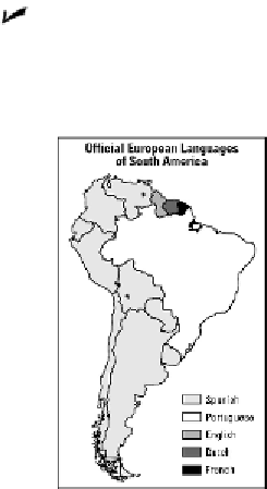
Figure 5-6:
This
map uses nomin-
al area symbols
to identify lan-
guages of South
American coun-
tries.
Gathering
Information:
Sources
for
Pinpointing
Objects
Few things are more important in cartography than the positional accuracy of mapped objects. His-
torically, this was accomplished by field observation. That is, explorers or surveyors would travel to
a particular area, observe locally important features, and map their locations.
Nowadays, GPS technology has greatly contributed to positional accuracy (see Chapter 3). In
addition, many maps and the things that they show are products of
remote sensing.
In techno-
speak, this refers to gathering information from afar about the Earth. In everyday English, it
refers to use of aircraft and satellites to take pictures and picture-like images of Earth.