Geology Reference
In-Depth Information
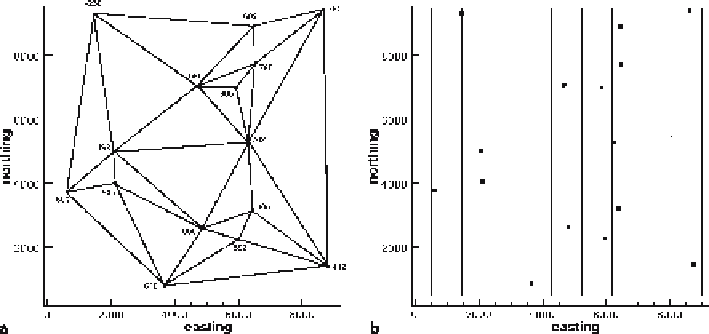
Fig. 3.6.
Methods for relating control point elevations to each other.
a
Triangulated irregular network
(TIN) with data points at the vertices.
b
Grid superimposed on the data, elevations will be interpolated
at the grid nodes
data are on a regular grid, other operations, such as the calculation of the distance
between two gridded surfaces, are relatively easy. The major disadvantage is that the
contoured surface does not necessarily go through the data points and it may be dif-
ficult to make the surface fit the data.
3.4.2
Triangulated Irregular Networks
Creating a TIN requires determining the nearest neighbor points, between which the
contours will be located. The possible choices of nearest neighbors are seen by con-
necting the data points with a series of lines to form triangles (Fig. 3.7a). The points
could be connected differently to form different networks. Delauney triangles and
greedy contouring are two unbiased approaches to choosing the nearest neighbors.
The commonest form of triangulation is in two dimensions and considers only the
proximity of the points in a plane, such as
x
and
y
but not
z
. Triangulation in three
dimensions considers the
xyz
location of points and can be generalized to interpret
very complex surfaces (Mallet 2002).
3.4.2.1
Delauney Triangles
A Delauney triangle is one for which a circle through the three vertices does not in-
clude any other points (Jones and Nelson 1992). In Fig. 3.7b, the solid circle through
vertices a, b and c is a Delauney triangle because no other points occur within the circle.
The vertices of the triangle are nearest neighbors. The dashed circle through vertices a, b
and d (Fig. 3.7b) includes point c and therefore does not define a Delauney triangle.
This method is not as practical for use by hand as the next technique.