Geology Reference
In-Depth Information
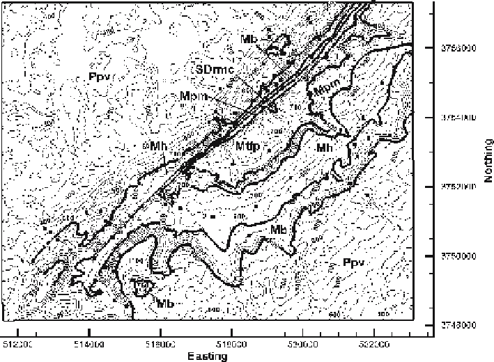
Fig. 2.4.
Geologic map of a portion of the southern Sequatchie anticline in the vicinity of Blount Springs,
Alabama. Base map is a DEM. The units are, from oldest to youngest, Silurian Red Mountain Formation
and Devonian Chattanooga Shale (
SDrmc
), Mississippian Tuscumbia Limestone and Fort Payne Forma-
tion (
Mtfp
), Mississippian Pride Mountain Formation (
Mpm
), Mississippian Hartselle Sandstone (
Mh
),
Mississippian Bangor Limestone (
Mb
), Pennsylvanian Pottsville Formation (
Ppv
).
Thick lines
are geologic
contacts,
thin lines
are topographic contours (50 ft interval). Horizontal scale is UTM in meters.
Solid
squares
are locations where bedding attitudes have been measured. (After Cherry 1990; Thomas 1986)
contacts are digitized, they can be visualized as part of the 3-D model (Fig. 2.5), edited
and otherwise manipulated digitally.
The geologic map of the Blount Springs area (Figs. 2.4, 2.5) will provide the data for
an ongoing example of the process of creating and validating a structure contour map.
The map area is located along the Sequatchie anticline at the southern end of the
Appalachian fold-thrust belt and is the frontal anticline of the fold-thrust belt.
2.2.3
Wells
The location of points in a well are measured in well logs with respect to the elevation
of the wellhead and are usually given as positive numbers. Depths in oil and gas wells
are usually measured from the Kelly bushing (Fig. 2.6a). The elevation of the Kelly
bushing (KB) is given in a surveyor's report included as part of the well-log header
information. Alternatively, depths may be measured from ground level (GL) or the
derrick floor (DF).