Geography Reference
In-Depth Information
13
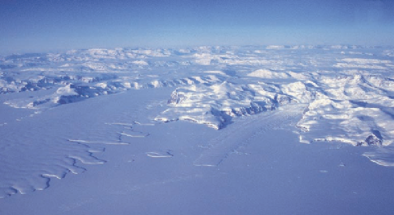
Figure 1.7. On a clear day
Ross viewed this portion of
the coastline of northern
Victoria Land, describing
it as “a scene of gran-
deur and magnificence.”
The prominent cliff face
slightly to the left of center
is Cape Sibbald, and the
prominent peak near the
right margin of the image
is Mount Monteagle. The
Aviator Ice Tongue issues
into the frozen surface of
the Ross Sea from the val-
ley behind Cape Sibbald.
The peak near the coastline
to the left of the Avia-
tor Ice Tongue is the site
where, on New Year's Day
1962, the Topo North sur-
vey party was nearly blown
off its station by katabatic
winds (Chapter 7).
crew.” It being Saturday, they joined in the seaman's toast to “Sweethearts and Wives—
May the sweethearts become wives and the wives remain sweethearts.” Then another gale
struck and drove them oV to the east for the next two days. Returning from the west the
ships encountered tight pack ice forty or fifty miles out from the shore. The crew had clear
views of the massive volcanic cone rising almost nine thousand feet out of the sea, which
was named Mount Melbourne, after Lord Melbourne, the British prime minister at the
time.
At noon on January 26 the magnetic field dipped at 88° 33′, putting the pole only 174
miles west of south, but Mount Melbourne lay only 40 miles to the west, and although
south of it the coast drew back to the west, farther on it straightened and headed due
south along the meridian. Rather than try to penetrate the pack that was holding them
oV from the mountains, Ross ordered his ships south, with hope of still rounding the
range and coming up on the magnetic pole from the south. But soon the expedition was
putting distance between itself and the pole. The next day Ross made a rough landfall at
Franklin Island, another small volcano of basalt, and again claimed possession. Thence
the ships headed south toward a peak that had appeared that morning and loomed in-
creasingly large across their course.
Ross recorded, “'High Island'; it proved to be a mountain twelve thousand four hun-
dred feet of elevation above the level of the sea, emitting smoke and flame in great profu-
sion; at first the smoke appeared like snow drift, but as we drew nearer, its true character
became manifest” (Fig. 1.8). How wondrous it must have been to discover this fountain
of fire in a land of ice! The active volcano was joined to an inactive one, rising to 10,900
feet. Ross named the twin cones Mount Erebus and Mount Terror, after the expedition's
ships. To Ross they appeared to be connected to the mountain range to the west, a mi-
nor error in an exceptional charting of new lands. With the south now blocked, the only
possible avenue to the pole would have to be found to the east, but as they sailed farther
south, an even more phenomenal specter rose out of the sea: