Environmental Engineering Reference
In-Depth Information
rates usually exceed precipitation rates in
late spring and summer. Hence, water storage
decreases during this period and the depth to
the ZFP increases. The ZFP usually reaches its
maximum depth in late summer, after which
time water storage begins to increase and, cor-
respondingly, the depth to the ZFP starts to
decrease. The depth to the ZFP can decrease
rapidly in response to a large rainfall at any
time of the year (
Figure 5.5
).
Locating the depth of the ZFP requires accur-
ate measurement of hydraulic head at multiple
depths within the unsaturated zone. As dis-
cussed in
Section 5.2.2
, tensiometers are com-
monly used for these measurements (Driess and
Anderson,
1985
; Cooper
et al
.,
1990
; Roman
et al
.,
1996
). The limited accuracy of tensiometers and
other pressure-head sensors imparts a degree of
uncertainty to the estimated depth of the ZFP.
Additional uncertainty is introduced if sensors
are spaced too widely apart, in which case the
hydraulic gradient may be poorly defined.
The ZFP method is best applied in regions
that display a wide range of soil-water contents
throughout the year. The method is not limited
in terms of soil texture, but areas with shal-
low water tables and coarse-grained sediments
can pose a problem. In this type of environ-
ment, it is conceivable that a rapidly moving
wetting front could escape detection by travel-
ing from land surface to the water table during
the interval between water-content measure-
ments. The method provides useful results
under the proper conditions, but an alterna-
tive method needs to be used for times when
it breaks down (e.g. when water movement is
downward throughout the entire soil column,
as in profile A in
Figure 5.4
). The method inher-
ently assumes that water in the region below
the ZFP moves downward; features that pro-
mote horizontal flow in the unsaturated zone,
such as layering or variability in texture, can
complicate its application.
1.2
1.0
ZFP
0.8
0.6
Rain
0.4
0.2
0
50
100
150
200
250
300 50
Julian date, 1972
Figure 5.5
Depths of zero-flux plane (ZFP) and
cumulative rainfall over a 10 month period for a field near
Ambeliet, southwestern France (Royer and Vachaud,
1974
).
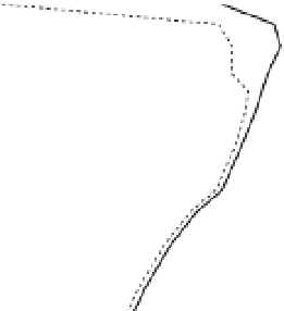
0
0.5
1
1.5
2
May 15
May 30
June 21
Aug 28
2.5
3
-600
-400
-200
0
Total head (mm)
Figure 5.6
Total head profiles and locations of zero-flux
plane (arrows) at the Bicton College site in 1989 (Cooper
et al
.,
1990
; reprinted with permission of John Wiley &
Sons, Inc.).
precipitation or irrigation events could be
problematic for application of the ZFP method
unless head and water-content readings are
automatically recorded. For cases where irriga-
tion is applied three or four times per year the
method may work well.
Under natural conditions in humid regions,
the depth of the ZFP follows a somewhat pre-
dictable pattern. In late winter and spring, when
evapotranspiration rates are low, water storage
in the unsaturated zone increases and the ZFP
rises close to land surface. Evapotranspiration
Example: Chalk and Triassic Sandstone
aquifers, England
Seven sites were instrumented for applica-
tion of the ZFP method to estimate drainage
to the Chalk and Triassic Sandstone aquifers