Geography Reference
In-Depth Information
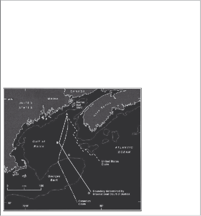
Box 26.2
Canada-United States Gulf of Maine maritime boundary
(Resolved by a Chamber of the International Court of
Justice, October1984.)
case. It took nearly four years for the evidence to be
prepared and the case heard. In the event, geographical
considerations were of paramount importance.
The court rendered its judgement in October 1984,
proposing a line in three sectors. A—B was delimited by
drawing the bisector of an angle determined by
perpendiculars to the general direction of the adjacent
coasts. B—C started as an equidistance line between
opposite coasts but was adjusted in the ratio of 1.32:1 in
favour of the USA to reflect the greater length of the US
coast in this sector. C—D was determined as a
perpendicular to the closing line of the gulf, to a distance
of 200 nautical miles offshore. The sector between the
land boundary and point A remains undelimited because
of a sovereignty dispute over Machias Seal Island
(Charney and Alexander 1993: pp. 401-16).
The Gulf of Maine is geographically complex and of
considerable economic importance because of the rich
fisheries on George's Bank. Canada and the USA tried
very hard to delimit a maritime boundary there but after
five fruitless years of negotiation, in 1981 they asked a
Chamber of the ICJ to delimit a single continental shelf
and fisheries boundary. It was a formidable task. The
Canadians claimed a median line between mainland
coasts, giving them a large part of George's Bank. The
USA argued for a line perpendicular to the general
direction of the coast and for control of the whole of
George's Bank (Figure 26.4). More scientific, legal,
economic, social and historical data were assembled to
support the arguments of the parties than for any similar
Figure 26.4
The Canada-
United States maritime
boundary in the Gulf of Maine
(resolved 1984).
extremely tricky issues to settle. The most
important aspect, however, was the political will
of the parties to reach a peaceful agreement.
km
2
) of contested territory. Apart from size, the
dispute has some potent ingredients for a
dangerous confrontation, including a remote
mountain environment, geostrategic objectives,
ideological differences, and the legacy of British
imperial involvement. Although the problems go
back at least to the beginning of the century,
Chinese claims were not pressed until after the
China-India
The 2500 mile (4000 km) China-India boundary
(Figure 26.7) involves 32,000 square miles (83,000