Geography Reference
In-Depth Information
•
Tidal datums
. States adopt different criteria for
the measurement of low water marks, which
can affect the definition of low-tide
elevations, and the selection of basepoints for
baseline delimitation.
difficult to resolve. Where inter-state relationships
are poor, perhaps for historical or ideological
reasons, negotiations may be impossible or
extremely difficult, as China-India and Greece-
Turkey illustrate. Where the territory or seabed in
question is of high economic potential
(Cambodia-Thailand, Saudi Arabia-Yemen, for
example) or is regarded as strategically critical
(China-India, Greece-Turkey), compromise is
unlikely. Significantly, too, in all the chosen
examples there are perplexing legal, historical and
geotechnical questions, which require time,
money and expertise to answer. By contrast, Boxes
26.1 to 26.4 illustrate four disputes that have been
successfully resolved, although there were
BOUNDARY DISPUTES AND DISPUTE
RESOLUTION
Unresolved disputes
Four unresolved disputes (two land and two
maritime) are briefly outlined in this section to
illustrate why certain boundary disputes can be
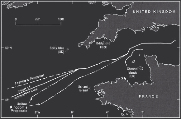
Box 26.1
France-United Kingdom continental shelf
recognised as a legitimate basepoint. Because of their
distance beyond UK territorial waters, the Scillies were
given only half effect. This was achieved by drawing a line
following the French and UK mainlands, and another
treating the islands as mainland. A line was drawn to bisect
these two equidistant lines (Francalanci and Scovazzi 1994:
pp. 238-9).
In March 1978, the court made adjustments to the
line as a result of UK complaints that the court line was a
loxodrome, or straight line, on a Mercator chart that took
no account of the curvature of the Earth. At its western
extremity, it lay four nautical miles north of the correct
position and was accordingly adjusted in favour of the
UK (Jagota 1985: pp. 140-55).
(Resolved by a Court of Arbitration, June 1977.)
France and the United Kingdom (UK) could not agree on
a continental shelf boundary in the western approaches
to the English Channel, and in 1975 they asked a Court
of Arbitration for a solution. The chief problems were how
far to take into account the UK Channel Islands lying
close to the French coast, Eddystone Rock and the Scilly
Isles (both UK features), and the French isle of Ushant
(Figure 26.3). The court's decision was announced in
June 1997. The Channel Islands were enclaved within
twelve mile territorial seas, and median lines with the
French mainland to south and east, while Eddystone was
Figure 26.3
The France-United
Kingdom continental shelf
boundary (resolved 1977, 1978).