Environmental Engineering Reference
In-Depth Information
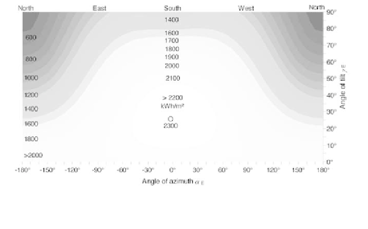
Figure 2.17
Annual Irradiation on Various Inclined Surfaces in Cairo
(30.1°N)
In the southern hemisphere, the optimum tilt angles are similar, with the
optimum surface azimuth facing the equator, i.e. north. Close to the equator,
very flat tilt angles are ideal because the sun is in the zenith for long periods of
time. Therefore, the irradiation losses for vertical surfaces are much higher at
low latitudes.
C
ALCULATION OF
S
HADING
L
OSSES
All calculations in the previous sections have assumed that the irradiance is
not reduced as a result of shadows of objects in the surroundings. Totally
unshaded surfaces are difficult to find in reality. Shading can cause high losses
of performance for solar energy systems, in particular for photovoltaic systems.
Therefore, the following sections explain how shadowing can be taken into
account for the irradiance calculations.
Recording the surroundings
This section uses the example of a photovoltaic system to be installed on the
roof of a detached house. Various trees and bushes as well as another house
are in the vicinity of the building and might affect the irradiance that could be
collected by the system. First, the point of reference must be defined. The point
with the highest probability of being in shadow is the best choice. All azimuth
and height angles will then refer to this point.
In the next step, all azimuth and height angles of the objects in the
surroundings must be estimated with respect to the point of reference. A
compass can be used to find the azimuth angle
α
. Simple geometrical
calculations can estimate the height angle
γ
as shown for a tree in Figure 2.18.