Geography Reference
In-Depth Information
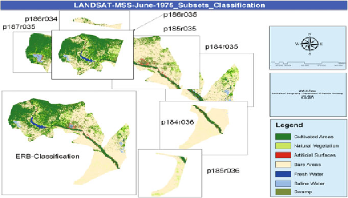
Fig. 5.49 LANDSAT-MSS-data-June-1975 classification results for each subsetted image and
the mosaicing of all results in one thematic map
classification results to produce one final thematic map (Fig.
5.49
). The procedures
that were performed in the classification were: (1) Creation of the legend including
the LULC-classes to be classified based on LCCS-scheme (see
Sect. 5.3
); (2)
Selection of the training samples visually from the MSS-data itself; (3) Calculation
of the separability values for the selected training samples (see
Sect. 5.6
); (4)
Application of the MLC-algorithm that offered the best accuracies (see
Sect. 5.7.2
); and (5) Validation of the classification accuracy using the accuracy
assessment methods (see
Sect. 5.13
).
5.9 Irrigated Areas Mapping
As shown in the information obtained from the Syrian Irrigation Ministry, the total
reclaimed lands in the Euphrates River Basin in the period 1970-2007 comprised
some 201,372 ha, distributed in the governorates of Aleppo(72,492 ha), Arraqqa
(102,512 ha) and Deir Azzour (26,367 ha). However, the variation in the radio-
metric characteristics over the various imagery that were used to construct the final
mosaic-images and the variation in the spectral, spatial and radiometric charac-
teristics over the various multi-sensor datasets, added their own uncertainties to
irrigated area estimates.
This section describes the methodology used to locate irrigated areas within the
national administrative units in the Euphrates River Basin. Irrigation maps were
derived from remotely sensed data (LANDSAT-MSS-June-1975, LANDSAT-TM-
May-1987 and 2007, and TERRA-ASTER-May-2005), and from the very detailed
Search WWH ::

Custom Search