Geography Reference
In-Depth Information
Fig. 5.18
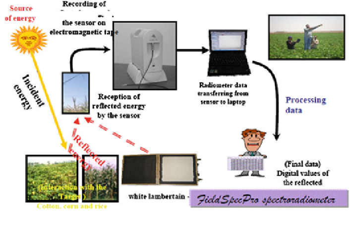
The followed concept in spectral measurements using (FieldSpecPro) by (GORS)
The questions related to the spectral characteristics of the used data are: what
are the agricultural features that have to be classified? Are they spectrally sepa-
rated from the other associated agricultural features and land cover types (espe-
cially the natural plants)? Which EMS portion, wavelength, or spectral band are
most helpful for spectrally distinguishing and classifying the agricultural features?
and what time period of the year is more suitable, in which remote sensing data
would be acquired? This based on the fact that the spectral behavior of these
agricultural features is unique or more unique during certain times of the year
(Hoffer
1980
).
The conceptual method and the final results carried out from the GORS-project
(see
Chap. 2.2
) using the spectrometer measurements were used to determine the
appropriate date/s, in which is it was possible to separate between the agricultural
crops spectrally and then to classify the individual winter and summer crops. This
presentation was to confirm the temporal choice of the various remotely sensed
data that are used in this study.
A FieldSpecPro spectrometer by GORS was used to collect the radiometric
measurements of the major crops. It had a spectral range of 350-2,500 nm, with a
spectral interval of 1 nm. It offered very sensitive and accurate measurements in
the spectral ranges of visible, near infra-red, far infra-red, and thermal, and was
equipped with two software-programs. The first, RS3, recorded target reflectance
and saved the measurement records. The second, ViewSpecPro, processed the
recorded
data
and
transformed
them
to
digital-format,
for
ease
of
analysis
(Fig.
5.18
).
Search WWH ::

Custom Search