Geography Reference
In-Depth Information
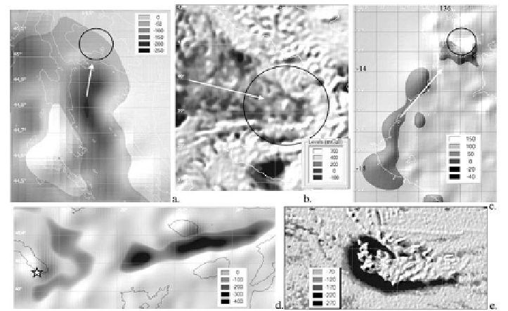
Figure 36. Tail-shaped gravity lows according to ENDDB that accompany potential
underwater astroblemes: a) Krk (D=14 km, 40.4 Ma), b) Tyrrhenian Basin (D=200 km,
0.01 Ma), c) Bickerton Island (D=30 km), d) Athos (the observation point of
2003.07.21 is asterisked), e) Galapagos (D=14 km). Images (a) and (c) are obtained
with V15.1; the other maps of this and previous figures are obtained with V18.1 [72].
The scale shows gravity in mGal.
Visual observation of submerged craters is difficult, and analysis of
geophysical evidence in this case is simpler than the analysis of morphology.
The surface gravity anomalies mimic the round shapes of well-preserved
craters, which can be assigned to impact structures in the presence of a tail
(Figure 36) even if no gravity data is available to reveal rootless anomalies.
This assignment may be the first step in a complex study of submerged impact
structures, when in addition to the standard geological and geophysical
mapping methods there are such exotic ones as paleographical reconstructions
of tsunami waves with location of the impact origin, or, for example, location
of ring clouds and zones of oceanic heat flow anomalies [61].
Typical Structural Elements of Seismicity Identified in GIS
Digital Models
The ENDDB (as well as its prototype GIS EEDB) software offers special
methods for grouping related earthquakes: grouping earthquakes generated by