Geology Reference
In-Depth Information
More important, in Oregon, this final extensio-
nal phase exerted differential pressure to spin or twist
much of the state 60 degrees in a clockwise direction.
One estimate is that extension of the basin is responsi-
ble for only 60% of the total rotation. The remaining
40% of rotation may be due to structural phenomena
called "dextral shear" where the basin of Oregon is
caught between two massive shifting blocks. As the
west block moves north and the east block moves
south, Oregon is rotated in a clockwise direction.
The spreading itself has created a distinctive
pattern which has been recognized in Nevada with
respect to gravity anomalies. The anomalies are
mapped as high and low gravitational values across an
area. This means that over a gravity low, for example,
an object actually weighs less or there is less gravita-
tional attraction compared to a gravity high. By careful-
ly measuring and plotting the gravity map for the basin,
it has been shown that the pattern in the region east of
the 116 degree meridian is strikingly similar to that in
the area west of the meridian. This near mirror image
or twinning display of gravity data seems to support the
thesis that a Basin and Range extension relates to
some type of sub-crustal spreading mechanism.
Volcanism and Tectonics
In addition to the crustal stretching phenome-
non, massive volcanism in this province was connected
directly to movement of the crustal plates. Four
tectonic plates, the Kula, Farallon, Pacific, and North
American, converged at the North American West
Coast during late Cretaceous and early Tertiary time.
The Kula plate gradually disappeared northward under
Alaska, while the Farallon plate was subducted east-
ward under North America. As the Farallon and Kula
plates slowly sank beneath the North American plate,
the Pacific plate expanded until today it is adjacent to
the North American plate along the West Coast.
Remaining fragments of the trailing edge of the old
Farallon plate have been named the Juan de Fuca
plate.
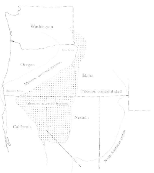
Possible Paleozoic accreted terranes in the Oregon
Basin and Range are obscured by layers of youn-
ger Tertiary volcanics.
million years ago was responsible for opening the
Nevada-Oregon rift, the western Snake River down-
warp or graben, and crustal fractures in eastern Oregon
which in turn gave rise to volcanic dike swarms that
released Steens Mountain and Columbia River basalts.
A second sequence of Basin and Range extens-
ional tectonics during the last 10 million years gave the
basin its characteristic topography of fault-block
mountains interspersed with depressions. The complex
mosaic of cracks and faults here line up in two distinct
trends, one to the northwest and the other to the
north-northeast. The result is that basins formed by
faults tend to be open at the north end and form a "V"
at the southern end. Northwest trending faults in this
system are relatively small showing only about 150 feet
maximum displacement with spacing of about a mile.
Faults running in a northeast lineup, by contrast, are
several miles apart and show displacements of thou-
sands of feet.
The angle of the subducting slah beneath the
overriding plate is critical to the location of surface
volcanic activity. Typically the volcanic archipelago is
situated in a line on the overlying plate where the
melting slab is 90 miles below within the crust. When
the collision rate between two plates is slow, the angle
of the subducting plate is steep, and the volcanic arc
will be close to the subduction zone. As the conver-
gence rate increases, the angle becomes very low and
flat, and the archipelago of volcanoes will move toward
the continent far from the subduction zone. As the rate
of converging plates accelerated at the Mesozoic-
Cenozoic boundary between 70 and 50 million years