Geology Reference
In-Depth Information
responsible for thick ash and stream-deposited sedi-
ments in the basin and Owyhee uplands.
During the Pliocene and Pleistocene increased
rainfall was responsible for large lakes filling the
basins. These lakes have since dried up or diminished
considerably because of more arid conditions prevailing
today. The colder climate of the Pleistocene also
brought about a build-up of ice masses atop Steens
Mountain. Relatively recent volcanism has created
some unique topography at the lava fields of Diamond
Craters, Saddle Butte, and Jordan Craters.
Extensional Tectonics
Beginning in the Miocene and extending into
the Pliocene, the forces of crustal stretching and the
movement of tectonic plates triggered faulting, exten-
sive volcanism, and the development of the basin and
fault block mountain topography characteristic of this
province. The most profound effect of tectonics in the
Basin and Range is an east-west stretching, extensional
phenomena that has expanded this province by as much
as 100%
One interesting aspect of the extension in this
province has been the clockwise shift in the stretching
direction from northeast-southwest to a more north-
west-southeast orientation. When the crust of the basin
was pulled and drawn apart, it grew thinner like a piece
of taffy being stretched. With additional tension, the
thin, semi-brittle crust began to fail producing faults
which provided a route for magma in the lower crust to
escape to the surface as widespread lava flows and
volcanoes. The thinning also brought the water table
into contact with the hot crustal rocks below so that
Nevada and southern Oregon today have scattered
thermal springs and explosion craters or maars situated
above ancient and modern faults.
Forces responsible for the stretching of the
Basin and Range are still not well-understood. It is
possible the basin may be above a spreading backarc
that is near the western margin of North America.
Alternately, the basin may represent a plate moving
westward over a mantle plume or even an oceanic
spreading center that has been overridden by the North
American plate.
The extensional tectonics occurred in two
distinct phases. An early event between 20 and 10
Geology
If Oregon has a foundation block upon which
the rest of the state was constructed, it is buried under
the Basin and Range province. In the Blue Mountains
and Klamaths, the movement, amalgamation, and
eventual accretion of late Paleozoic and Mesozoic
exotic terranes to North America can be readily
demonstrated. By contrast, the volcanic veneer of the
Basin and Range region obscures its preCenozoic
history, and older rocks here could predate the accre-
tion of terranes of the Blue Mountains and Klamath
provinces. However, recent geophysical work on the
northern Basin and Range suggests that the crust is
even thinner than previously thought. This means that
the Miocene volcanics may, in fact, represent the
basement or oldest rocks of the province.
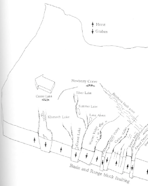
Extensional tectonics in the Basin
and Range yield steep-walled valleys
that open northward. This portion
of Oregon may have stretched to
twice its original width (after
Wells and Heller, 1988).