Geography Reference
In-Depth Information
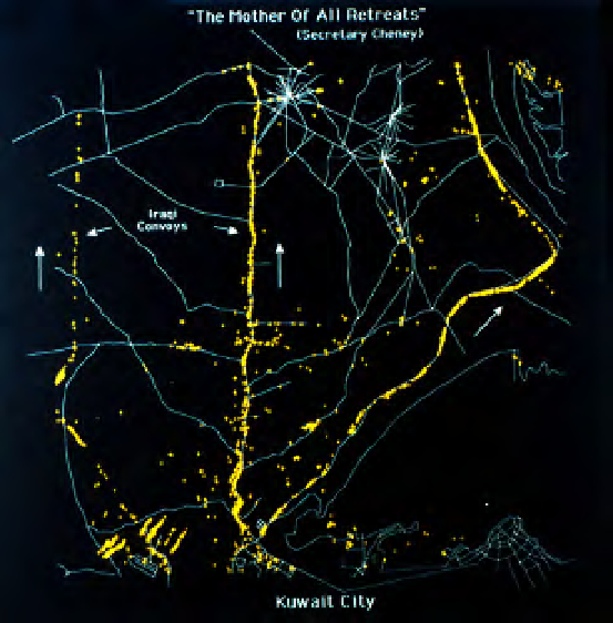
ThisJ-STARSmap,showingIraqiconvoysleaving
KuwaitCity,istitledandannotatedbyGrumman
Corporation.
PHOTO: GRUMMAN CORPORATION
retreating Iraqi convoy stretching two miles along the only six-lane highway north
from Kuwait City across the border to Basra, and U.S. pilots destroyed it at the
Al-Mutlah Ridge.
23
According to General H. Norman Schwarzkopf's
It Doesn't Take a Hero
, other
images of that highway, taken from the ground, probably ended the war. “Journal -
ists were now interviewing...pilots who'd been hitting the convoys fleeing Kuwait
[and]...reporters who had once been part of the media pools had taken pictures of
Highway 6, where we'd bombed a convoy Monday night .... Washington was ready
to overreact, as usual, to the slightest ripple in public opinion. I thought, but didn't
say, that the best thing the White House could do would be to turn off the damned
TV in the situation room.”
24
On this battlefield, the images were in combat and in turmoil.
And other satellites, not just U.S. and French, were also taking pictures over
Iraq and Kuwait. “Soviet satellite coverage over Kuwait resumed on February 7th,”
reported
Armed Forces Journal International
, “when Kosmos 2124 picked up where
2108 left off. The replacement satellite was in an ideal position to gather 'convinc -
ing' photos on February 22nd—the day before [Iraqi Deputy Prime Minister Tariq]
Aziz's visit to Moscow. And, unlike its predecessors orbiting over Kuwait, Kos -
mos 2124 can return packages to earth while remaining aloft. We may never know
Search WWH ::

Custom Search