Geology Reference
In-Depth Information
100,000 deaths from the 1920 earthquake in Gansu, China,
resulted when cliffs composed of loess (wind-deposited silt)
collapsed. More than 20,000 people were killed when two-
thirds of the town of Port Royal, Jamaica, slid into the sea
following an earthquake on June 7, 1692.
One long-range prediction technique used in seismi-
cally active areas involves plotting the location of major
earthquakes and their aftershocks to detect areas that have
had major earthquakes in the past, but are currently inactive.
Such regions are said to be locked and not releasing energy.
Nevertheless, pressure is continuing to accumulate in these
regions because of plate motions, making these
seismic gaps
prime locations for future earthquakes. Several seismic gaps
along the San Andreas fault have the potential for future
major earthquakes (
A successful prediction must include a time frame for the
occurrence of an earthquake, its location, and its strength.
Despite the tremendous amount of information geologists
have gathered about the cause of earthquakes, successful
predictions are still rare. Nevertheless, if reliable predictions
can be made, they can greatly reduce the number of deaths
and injuries.
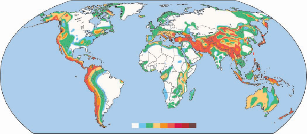
From an analysis of historic records and the distribution
of known faults, geologists construct
seismic risk maps
that
indicate the likelihood and potential severity of future earth-
quakes based on the intensity of past earthquakes. An inter-
national effort by scientists from several countries resulted
in the publication of the fi rst Global Seismic Hazard Assess-
ment Map in December 1999 (
Figure 8.19). A major earthquake that
damaged Mexico City in 1985 occurred along a seismic gap
in the convergence zone along the west coast of Mexico.
Earthquake precursors that may be useful in making
short-term predictions include slight changes in elevation
and tilting of the land surface, fl uctuations in the water level
in wells, changes in Earth's magnetic fi eld, and the electrical
resistance of the ground.
◗
Currently, only four nations—the United States, Japan,
Russia, and China—have government-sponsored earth-
quake prediction programs. These programs include labora-
tory and fi eld studies of rock behavior before, during, and
after large earthquakes, as well as monitoring activity along
major active faults. Most earthquake prediction work in the
United States is done by the U.S. Geological Survey (USGS)
and involves research into all aspects of earthquake-related
phenomena.
The Chinese have perhaps the most ambitious earthquake
prediction program in the world, which is understandable
considering their long history of destructive earthquakes.
Figure 8.18). Although such
maps cannot be used to predict when an earthquake will take
place in any particular area, they are useful in anticipating
future earthquakes and helping people plan and prepare for
them (see Geo-Focus on page 213).
◗
Studies conducted during the past several decades indicate
that most earthquakes are preceded by both short-term and
long-term changes within Earth. Such changes are called
precursors
and may be useful in earthquake prediction.
Peak Ground Acceleration (m
2
s
2
)
2.4 3.2 4.0 4.8
0
0.2 0.4 0.8 1.6
0
1000
2000 3000 Kilometers
◗
Figure 8.18
Global Seismic Hazard Assessment Map The Global Seismic Hazard Assessment
Program published this seismic hazard map showing peak ground accelerations. The values are based
on a 90% probability that the indicated horizontal ground acceleration during an earthquake is not
likely to be exceeded in 50 years. The higher the number, the greater the hazard. As expected, the
greatest seismic risks are in the circum-Pacifi c belt and the Mediterranean-Asiatic belt.

Search WWH ::

Custom Search