Geoscience Reference
In-Depth Information
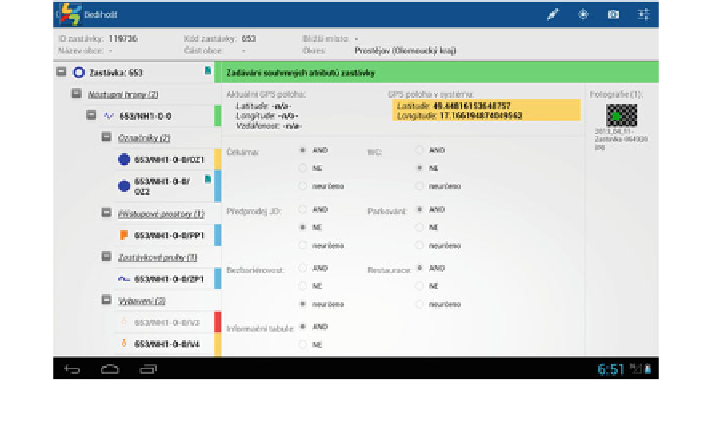
Fig. 5 Example of the MAPDD application form for editing basic data on the Bediho
šť
stop
in the form of check boxes where only one option can usually be selected. In the
field data collecting application, attribute values may be selected from more than 25
codelists; several other codelists work only to allow moves within the entity tree.
Entering from the keyboard is minimised to decrease the risk of non-uniform or
incorrect entries in the sense of entering various strings for the same aspect. The key
codelist is the stop ID codelist from CIS J
and derived complete names of all stops
comprising codelists for the names of towns, parts of the towns and speci
Ř
c
locations which the
field worker cannot modify (in other codelists it is possible
to add extension of the codelist in comments or select the
option). Thanks to
this measure, editing of a non-existing stop is avoided. Besides the elimination of
logic mistakes, entering of incorrect values resulting from misunderstanding or poor
knowledge is dealt with. Help is attached to some attributes or codelists in case the
“
other
”
field worker is not sure of the variant of the codelist value or they do not understand
the sense of the entered attribute. Apart from texts, the help often contains pictures
for clearness.
7 User Aspects of MAPDD
The data will prevailingly be used by the of
cials who manage the PT network,
potentially change the routes or names of the stops, create synoptic maps and
provide information reports and notices for general public. So far the KIDSOK staff
only worked with a point layer where each record represented a stop with all its
compounds in one point. Upon these data, they elaborated synoptic maps for
passengers and source materials for internal purposes (negotiations on integrating
Search WWH ::

Custom Search