Geology Reference
In-Depth Information
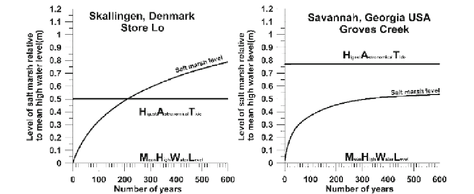
Fig. 8.19
Comparison between modelled salt marsh accretion in the Wadden Sea (
left
) and at the east coast of USA (
right
)
8.6
Salt Marshes in the Geological
Record
and the mean tidal conditions (repeated) at the har-
bour of Esbjerg (Denmark) and at Fort Pulaski located
at the entrance of the Savannah River in Georgia
(USA). The mean tidal range in Esbjerg is ~1.5 m and
at Fort Pulaski ~ 2.1 m. The initial salt marsh level in
both places is taken as the mean high water level and
the used
b
-value is at Skallingen put to 90 mg/l (a
typical value from Bartholdy et al.
2010a
) and in
Georgia to 230 mg/l (judged as a typical value at
Sapolo Island a little south of Savannah, from Howard
and Frey (
1985
)). It is apparent that the wind-tide-
affected salt marsh (Fig.
8.19
left
) relatively quickly
(~200 years) accretes up to a level above the highest
astronomical tide (HAT) and continues to accrete
beyond this level, whereas the almost solely astro-
nomical controlled salt marsh (Fig.
8.19
right
) most
likely will never reach that level. Even after 600 years
of deposition, the salt marsh level here is still as much
as 20 cm lower than
HAT
. These model results refl ect
and quantify general observed differences between
the relatively dry salt marsh areas along the North Sea
coast (capable of being grassed by cattle in the sum-
mer time) and the constant soft, muddy and wet salt
marsh areas along the east coast of USA. Frequent
wind-tide setup events above the level of
HAT
enable
the Wadden Sea salt marsh to grow above this level,
whereas the growth of the Georgian salt marsh will,
even if the b -value is more than twice that of the
Wadden Sea example, accrete asymptotically towards
the highest astronomical level which is not exceeded
under stable sea-level conditions.
Salt marsh deposits are found in a number of coastal
depositional environments. Following the classifi ca-
tion of Boyd et al. (
1992
, Fig.
8.20
), salt marshes can
exist on open tidal dominated coasts under transgres-
sion as well as regression/progradation. During trans-
gression, salt marsh deposits typically form in the
inner part of wave-dominated estuaries and they are
abundant along the entire coast of tidal dominated
estuaries. This is also the case along coastal lagoons
sheltered from the open coast by barriers. Deltas form
a special case of prograding coastal areas where salt
marsh deposition is widespread. Viewed separately,
salt marsh formation is independent of coastal type,
and will in general look the same and be associated
with the same primarily morphological features no
matter where it develops. This, as already discussed, is
a result of the fact that salt marsh deposition is depen-
dent on a special combination of vegetation, water-
level variation, underlain topography, sediment supply
and dynamical relations. Regardless of where this
combination appears, it will result in basically the
same type of sedimentation. Variations like those
related to, for example, degree of wave exposure, tidal
range and the occurrence of ice rafting will, of cause,
give rise to variations in morphology. However, such
variations can occur more or less, regardless of the
coastal types defi ned by Boyd et al. (
1992
) . It is pos-
sible to have both large and small tidal ranges on a