Geology Reference
In-Depth Information
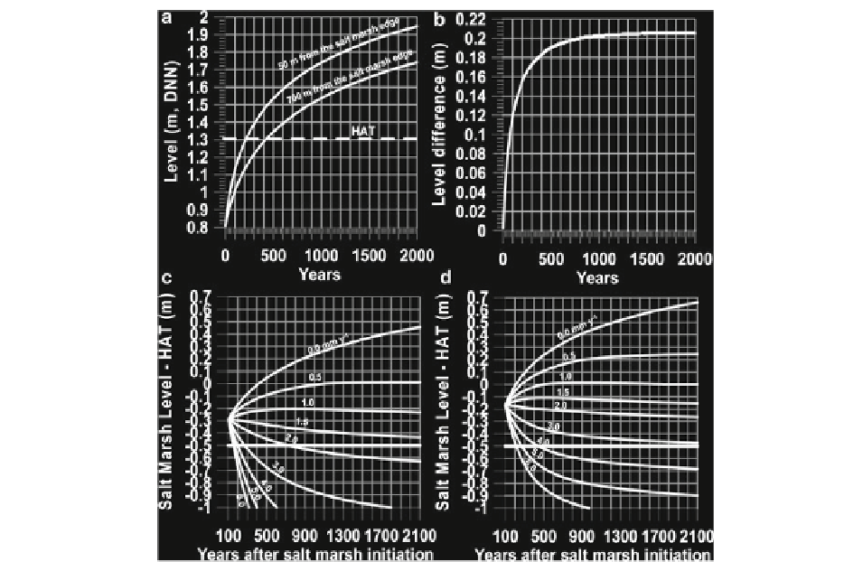
Fig. 8.18
(
a
) Simulated growth of the outer and inner salt marsh
at Skallingen based on a constant sea level and tidal conditions
corresponding to those present in the period 1949-2007. (
b
)
Simulated level difference between the outer and inner salt marsh
at Skallingen under similar conditions as those in
a
. (
c
) Simulated
difference between highest astronomical tide (
HAT
) and salt
marsh level under different sea-level rise scenarios at the inner
part of the Skallingen salt marsh. The tidal conditions are similar
to those present in the period 1949-2007 conservatively raised
parallel to the rising sea level. The simulation starts at present,
about 100 years after salt marsh initiation. (
d
) Simulated
difference between highest astronomical tide (
HAT
) and salt
marsh level under different sea-level scenarios at the outer part of
the Skallingen salt marsh. The tidal conditions are similar to
those in
c
. The simulation starts at present, about 100 years after
salt marsh initiation. The fat horizontal line in
c
and
d
represents
the present level difference between
HAT
and the level where salt
marsh starts to form (From Bartholdy et al.
2010a
)
level relative to HAT - namely 0. The two salt marsh
locations would therefore both stabilize at a level
very close to
HAT
but not with the same sea-level rise.
A stable inner part would coincide with a development
where the outer part would grow towards the top of the
rising tidal frame, whereas a stable outer part would
coincide with a development where the inner part
would eventually drown. For any other sea-level rise
scenarios, both the inner and the outer salt marsh
would be in disequilibrium, either in a state of down-
ing or growing towards the top of the tidal frame. The
reason for the apparent paradox that a salt marsh area
can establish and grow during a sea-level rise which
eventually will be too high for it to keep pace with the
rising tidal frame (e.g. 1.5 mm year
−1
in Fig.
8.18d
) is
that along with the salt marsh growth, the level increase
of the salt marsh surface slows down because of auto-
compaction (Fig.
8.14
).
8.5.2.2 Relationship to Different Tidal
Conditions
The model can also be used to describe and quantify
variations in the development of different salt marsh
types. In Fig.
8.19
, the accretion of a wind-tide-infl u-
enced salt marsh in the Wadden Sea (Skallingen) is
compared to that of a predominantly astronomical
controlled salt marsh on the east coast of USA
(Georgia). The model is ran for a constant sea level