Environmental Engineering Reference
In-Depth Information
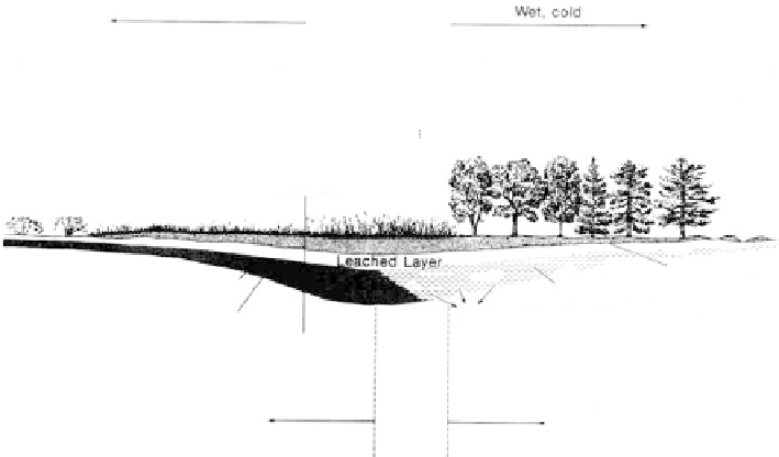
Dry, hot
Wet, cold
Desert
soils
Brown
soils
Chestnut
soils
Chernozem
soils
Prairie
soils
Gray brown
podzolic soils
Podzol
soils
Tundra
soils
Desert shrubs
Short grass
Tall grass
Broadleaf forest
Conifer forest
Tundra
100th
meridian
Leached la
y
er
Organic layer
Clay, iron accumulate
Carbonates removed
Calcium carbonate accumulates
Limit of soil water penetration
Alkaline soils,
closed system
Neutral
soils
Acid soils,
open system
FIGURE 7.116
Transect illustrating changes in soil profiles that accompany changes in vegetation and climate between the
tundra in northern Canada and the deserts in the Southwestern United States. At the 100th meridian, the
annual precipitation averages about 20 in.; there and to the west, the soils are alkaline. The easternmost
grassland soils are about neutral; farther east, the soils are acid. (From Hunt, C. B.,
Geology of Soils
, W. H.
Freeman and Co., San Francisco, 1972.
W. H. Freeman and Company. Reprinted with permission.)
Black
spruce,
cedar
Mixed hardwoods
Mixed hardwoods
Red maple
Oak, pine
Oak, pine
Red maple,
cedar
Till
Bog
Meadow
Gravel
Sand
Clay
Gravel
Bog
FIGURE 7.117
Relationship between vegetation and kind of ground in a glaciated Connecticut valley. Well-drained uplands
have mixed hardwoods; excessively drained gravel and sand have oak and pine. Poorly drained ground, on
clay, has meadow; upland bogs have black spruce and cedar; bogs in the alluvial valley have red maple and
cedar. Rocky promontories have scarlet, chestnut, and black oak. (From Hunt, C. B.,
Geology of Soils
, W. H.
Freeman and Co., San Francisco, 1972.
W. H. Freeman and Company. Reprinted with permission. See also
topographic map in
Figure 7.91.)
•
In Maryland, weathered serpentine, rich in magnesium but deficient in other
minerals, contains dwarfed vegetation.
•
In the Gulf states, from Texas to Alabama, growth on limy formations is
marked by belts of tall grass, whereas adjoining sandy formations support pine
forests.
•
Sections relating ground conditions to vegetation from two locations are shown:
a glaciated Connecticut valley (Figure 7.117; see also Figure 7.91, a topographic
map); and the Piedmont province in Maryland (
Figure 7.118).