Environmental Engineering Reference
In-Depth Information
Depth
(m)
Passaic River,
Newark, N J
Delaware River,
Pennsauken, N J
Anacostia River,
Washington, D C
Cape Fear River,
Wilmington, N C
Depth
(ft)
Fill - cinders
brick, etc.
Fill -
hydraulic sand
9
Water
Water
5
Very soft dark
gray organic silt
with shells
Dark gray
organic clay (OH)
fibrous
0
0
0
0
0
0
0
0
Soft gray organic
silt, occasional
sand layers
2
0
Soft dark
gray organic
silt
4
LL = 180
PI = 97
w
n
= 170
LL = 153
LL = 80
PI = 38
w
n
= 60
20
PI = 104
w
n
= 145
Organic silty sand
6
5
2
Fibrous organic
silt with shells
28
Gray silty
sand (SM)
- becoming sandy
Tan silty sand
10
11
becoming very
very sandy
Peat
31
48
12
20
Gray
silty sand
Red-brown
silty sand,
clayey silt
seams
Mottled red-
brown
silty clay to
clay (CH-MH)
40
0
28
24
24
17
15
Compact gray-
brown silty
gravelly sand
52
73
59
100
LL = 62
PI = 40
w
n
= 25
100
60
95%
Hard red
shale
72
59
26
- Silty sands
20
30
Legend:
Numbers in columns are
SPT or pecent recovery
LL - liquid limit (%)
PI - plasticity index
w
n
- natural water content (%)
72
121
137
Hard white
silty gravelly
clay
80
100
142
30
100
137
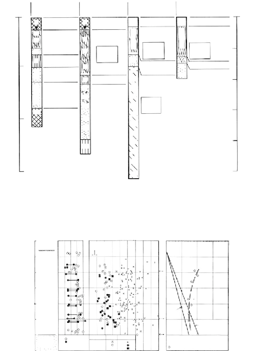
FIGURE 7.39
Logs of test borings made in estuarine environments at several U.S. east coast locations. All borings terminated
in the eroded surface that preceded submergence. (Courtesy of Joseph S. Ward and Associates.)
Typical
profile
at of
north
slope -3.0
W
N
,
W
L
,
W
P
, %
Undrained shear strength (psf)
Vertical effective stress (psf)
0
L
0
20
40
60
80
0
200
Remolded
field vane
400
600
800
0
500
1000
1500
2000
−
5
Soft
organic
silty
cloy
with
brown
shells
and
bits of
wood
chips,
some
sandy
zones
1095
−
10
vm
−
15
−
20
vo
1230
−
25
vo
without 5 ft
artesion pressure
1080
−
30
W
N
vo
- Net overburden stress
vm
- Maximum post pressure
vm
- from oedometer tests of and of
primary consolidation
Type of test
Field vane
unconfined
Tri, UU
Before After failure
Med - loose
silty sand
and gravel
W
L
and
W
P
−
35
From barings
before construction
FIGURE 7.40
Properties of estuarine soils (Fore River, Portland, Maine). Natural moisture contents at or above the
liquid limit indicate the deposit to be normally or underconsolidated. (From Simon, R. M. et al.,
Proceedings
of ASCE, Conference on Analysis and Design in Geotechnical Engineering
, Austin, Texas, June, Vol. I, 1974,
pp. 51-84. With permission.)