Geoscience Reference
In-Depth Information
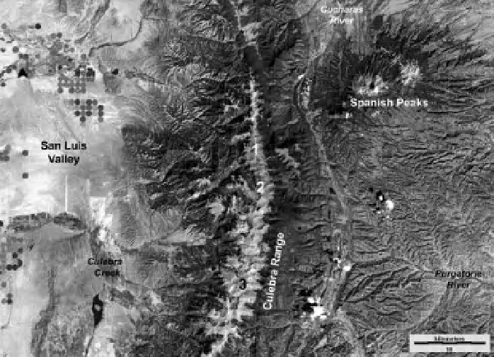
Figure 17-11.
Satellite image of Culebra Range and vicinity, south-central Colorado, United States. Selected peaks
along the mountain crest: 1. Trinchera Peak (13,517 feet, 4120 m), 2. Mt. Maxwell (13,335 feet, 4065 m) and 3.
Culebra Peak (14,069 feet, 4288 m). Based on Landsat TM bands 2, 5 and 7. Active vegetation is dark gray. Acquired
10 August 2010. Image from NASA; data processing by J.S. Aber.
is dominated by
Carex limosa
(mud sedge), and
the center is characterized by
Carex vesicaria
(blister sedge) (E. Volkova, pers. com. 2006). The
cottongrass is thought to be
Eriophorum angus-
tifolium
(tall cottongrass, Fig. 17-16A). Cotton-
grass is relatively scarce in montane wetlands of
Colorado, and this is the i rst report of it in
Huerfano County (U.S. Department of Agricul-
ture 2011). Green mosses are found on micro-
relief bumps, barely above normal water level
(Fig. 17-16B).
Several shallow and one long peat cores were
collected from the cottongrass fen (see Figure
3-31A). Sedge is the primary constituent of the
shallow peat along with green mosses, cotton-
grass, and various herbs with a low degree of
decomposition (E. Volkova, pers. com 2006); the
upper meter of peat is especially loose and
watery near the center of the fen. Toward the
margin of the fen, the peat is denser and made
up mostly of
Picea
(spruce) wood and bark.
Toward the center, the peat is up to 3.5 m thick
and rests on a silt bottom; basal peat is radio-
carbon dated at 1530 to 1340 calendar years
old (Beta 262070). This fen is relatively young
in terms of conditions suitable for peat
accumulation, and it is not yet close to trans-
forming into a raised bog.
Beaver mire
- Named for the obvious evi-
dence of past beaver activity, this mire has
highly varied vegetation cover, along with
numerous water channels, and several genera-
tions of beaver dams in different parts of the
mire complex (see Fig. 7-42). The overall shape
is elliptical, roughly 55 m
×
75 m in size, at
about 10,430 feet (3180 m) elevation. The beaver
dams are in a state of disrepair, and water level
is currently around half a meter below the crest
of the main dam. The mire is dominated by
Calamagrostis stricta
(slimstem reedgrass; E.
Volkova, pers. com. 2006). Bushy willows occupy
the western margin of the mire, and dead spruce
remain standing toward the eastern side (Fig.
17-17).
A long-term soil-temperature record has been
collected from near the center of the mire at a
depth of about 0.5 m (see Fig. 1-20). Peak tem-
perature of around 10 °C is achieved at the
end of summer (late September) (Fig. 17-18).
Throughout the autumn and winter, soil tem-
perature declines gradually, reaching a low just
above 0 °C in spring (March-May). Temperature