Geoscience Reference
In-Depth Information
2-10) as well as other sedimentary strata and
crystalline basement rocks. The crest of the
range is supported by thick quartzose sand-
stone, which is most resistant to erosion. Eleva-
tions along the crest generally exceed 3750 m
up to peaks higher than 4000 m. The lower
slopes of the range are covered by mixed
conifer-aspen forest, and above the treeline the
crest has alpine-tundra vegetation (see Fig.
17-10).
The Culebra Range was glaciated repeatedly
during the Pleistocene (Richmond 1965, 1986;
Armour, Fawcett and Geissman 2002), most
recently during the Pinedale Glaciation, about
23,000 to 12,000 years ago. Glaciers descended
from mountain sides, carved deep valleys with
rock basins, and deposited rubbly moraines in
those valleys, which created numerous closed
depressions. These basins are today sites for
lakes, fens, marshes and wet meadows (Fig. 17-
12), and beaver are quite active in downstream
creeks (Fig. 17-13). The Blue-Bear Lakes moraine
complex in the Cucharas Creek valley possesses
a variety of pothole habitats ranging from deep
lakes to mires with signii cant peat accumula-
tion (Fig. 17-14).
Two mires have been investigated in some
detail in the Blue-Bear Lakes moraine complex.
They are nearly identical in their overall physi-
cal settings in terms of climate, geology, and
surrounding spruce-aspen forest vegetation. The
substratum is composed of till rich in sandstone.
Both contain peat more than 2 m deep. Yet the
two mires are strikingly different in their mor-
phology, vegetation, and surface water.
Cottongrass fen
- This informal name indi-
cates the presence of cottongrass growing
around the margin of the fen. The fen is ellipti-
cal, about 40 m
A
B
C
Figure 17-10.
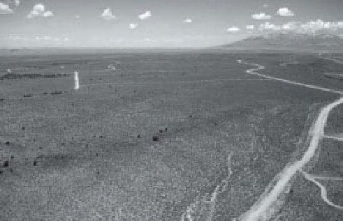
Climatic and environmental contrasts in
the Rocky Mountain region, southern Colorado, United
States. A. sagebrush desert of the San Luis Valley with
Blanca Peak (14,345 feet, 4372 m) of the Sangre de
Cristo Mountains in the right background. Blimp
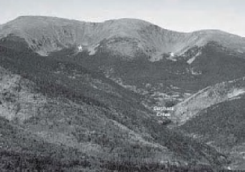
airphoto by S.W. Aber and J.S. Aber. B. Northern
portion of the Culebra Range seen from the east,
looking up the Cucharas Creek valley. Mixed conifer
and aspen forest covers the mountain slopes. Upper
forest limit is about 3500-3600 m. Two glacial cirques
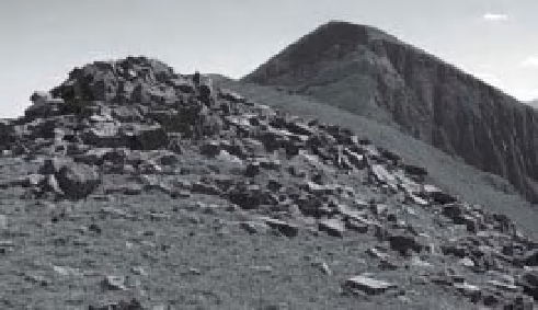
(*) are visible as basins at the heads of valleys. C. Crest
of the Culebra Range looking south toward Trinchera
Peak (13,517 feet, 4120 m). Sparse turf partly covers
quartzose sandstone bedrock in the alpine tundra. B
and C photos by J.S. Aber.
50 m in extent, and lies at an
altitude of approximately 10,380 feet (3165 m).
The surface is largely open, and shallow water
extends across the entire fen without any dis-
cernible l ow. This fen has a nearly ideal arrange-
ment of concentric vegetation zones and water
depths around its central point; the site displays
no evidence for beaver activity. The center of
the fen has somewhat taller emergent vegetation
and deeper water, and small spruce trees occupy
the western margin (Fig. 17-15). Most of the fen
×