Geoscience Reference
In-Depth Information
A
B
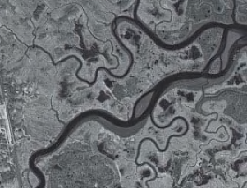
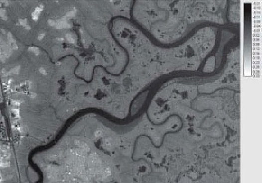
Figure 16-41.
High-resolution imagery of Rowley River study site (see Color Plate 16-41A). A. Near-infrared image
(April 2005) of the Rowley River salt-marsh system with a number of pools and pannes in black, active vegetation
in red across upland areas and marsh areas yet to green-up in pale shades of pink and gray. B. Adjusted
Normalized Difference Water Index (ANDWI) image. Wet pixels including pools, pannes, rivers, creeks and wet mud
are indicated by negative ANDWI values, while active vegetation is represented by positive ANDWI values. Data
source 1 : 5000 digital orthoimagery from Massachusetts Ofi ce of Geographic Information (MassGIS 2011). Adapted
from Pavri and Valentine (2008).
The vicinity of Rowley River, a tributary of
Parker River, has been investigated in some
detail. High-spatial-resolution digital orthoim-
agery from 2005 provides a detailed view of the
salt-marsh landscape (Pavri and Valentine 2008).
In this early spring season image (Fig. 16-41A),
a larger number of pools and pannes in black
are quite distinctive. Active vegetation appears
in red across the upland areas, while the marsh
itself appears in pale shades of pink or gray.
Green-up is yet to occur within the marsh and
hence the image still indicates the previous
year's dormant vegetation and dead matter.
Water is an essential component of a wetland,
and the spatial coni guration of marsh features
are often of some interest to ecologists and
wetland managers. An Adjusted Normalized Dif-
ference Wetness Index (ANDWI) provides one
way to easily distinguish pools, pannes and
saturated soils across a marsh from drier upland
zones (Hurd et al. 2005; Pavri and Valentine
2008). ANDWI values range between
indication of water levels in the creeks, channels
and drainage ditches.
Globally, coastal marshes are under threat
from development and the ramii cations of
climate and sea-level change. Some of the
highest population densities are found along
continental coastlines, threatening the produc-
tive capacity of estuarine zones. Even so, strong
economic arguments could be made for more
stringent protection of salt marsh. These systems
provide habitats necessary for commercially
viable i sheries, offer recreational opportunities,
and sustain tourism economies. These are indus-
tries of vital importance to both Maine and
Massachusetts. Maintaining the integrity of
coastal marsh systems, thus, not only serves
ecological purposes but provides equally impor-
tant economic benei ts.
16.4 Estonia, eastern Baltic region
−
1 and
+
1.
Pixel values closer to
1 are water-based pixels,
whereas those on the positive end of the spec-
trum are typically terrestrial based (Fig. 16-41B).
The ANDWI image easily distinguishes wet
areas from higher ground and provides some
−
The country of Estonia is situated at the eastern
end of the Baltic Sea and is surrounded by water
on four sides
-
Gulf of Finland to the north,
Baltic Sea to the west, Gulf of Riga to the south,
and Lakes Peipsi-Pihkva to the east (Fig. 16-42).