Geography Reference
In-Depth Information
25
1999
1989
22.5
20
17.5
15
12.5
10
7.5
5
2.5
0.123* X; R
2
= 0.97
Y =
−
0.13
+
0
0
20
40
60
80 100
120
140 160 180 200
Mean volume of wood introduced by bank erosion
(in m
3
per 250m of river reach)
(a)
(b)
(c)
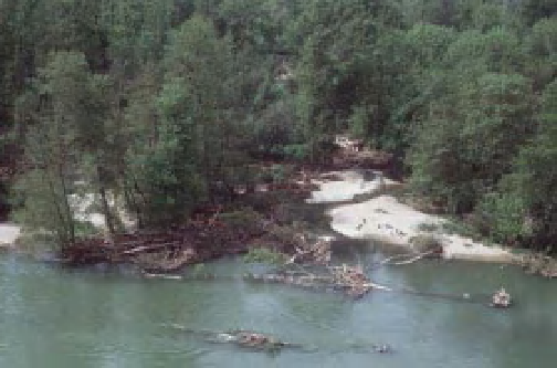
Figure 15.14
Results of the wood survey on the Ain River, France. (a) Relationship between the mean number of wood pieces
counted in oblique helicopter photos in 1989 and 1999 and the mean volume of wood recruited during the previous decade
(1991-2000 to be compared with 1999 observations, 1980-1991 for 1989 observations) per homogeneous depositional reach
(Modified from Lassettre et al., 2007). (b) and (c) examples of some of the photos used for this sensing.
cameras would also provide more efficient triggering
options while increasing the duration of battery life. Sub-
minute acquisitions are needed for characterising changes
but also understanding their controls with a higher
accuracy. New frontiers will also be crossed including
underwater acquisition. Waterproof video cameras have
recently been used to monitor suspended sediment on
the Colorado River by the USGS's Flying Eyeball (see
http://walrus.wr.usgs.gov/posters/flyingeyeball.html).
Recently, Fonstad et al. (2011) and Westoby et al. (2011)
showed it is possible to extract point clouds from a
set of overlapping close range photographs, though
a detailed ground control network is necessary to
register the cloud. The proposed 'structure from motion'
photogrammetric approach uses ordinary photographs
15.6 Forthcoming issues for river
management
Research based on large sets of ground photographs
is just emerging and advances in this domain are evi-
dently expected in the next 10 years. Technological
improvements in sensor quality, data storage, sensor
programming and power supply are likely to increase the
spatial and temporal resolution of imagery and facilitate
longer, unsupervised deployment periods.
New developments are necessary for automating pro-
cedures in order to permit the extraction of quantitative
information from pictures of dissimilar quality. Develop-
ing interfaces between physical sensors and close-range


Search WWH ::

Custom Search