Geography Reference
In-Depth Information
16000
FORMOSAT-2 Satellite
SPOT-5 Satellite
KOMPSAT-2 Satellite
AEROPLANE
POWERED PARAGLIDER
ULAVHELICOPTER
14000
12000
10000
8000
6000
4000
2000
0
0
10
20
30
40
50
60
70
80
90
100
Linear distance covered (km)
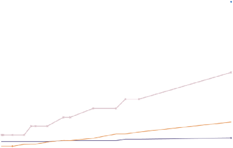
Figure 8.6
Cost estimates versus linear distance for a range of platforms.
mining are becoming increasingly important if the large
volume of data contained in hyperspatial image datasets
is to be effectively transformed into knowledge.
image' where variations in scale following variations of
topographic elevation are corrected and where the entire
image is reprojected in order to achieve rigorously con-
stant scale and resolution throughout. We can list three
main approaches to image georeferencing: A field-based
approach which requires ground control points (GCPs)
of known coordinates, an algebraic approach where the
position and attitude (i.e. orientation) of the camera at
the time of exposure is accurately known and an image
registration approach where a pre-existing, georeferenced
image of the same area is used to establish the position
of a new image. In practice, these three methods of geo-
referencing described here do not operate independently.
Multiple methods can be combined in order to improve
results. However, for the purpose of clarity, we will discuss
the three approaches independently.
Georeferencing a large volume of data is not straightfor-
ward. In the case of the field-based approach, the standard
procedure is to collect an absolute minimum 2 GCPs per
image in the case of 2D georeferencing. However, in order
to minimise errors, 3 to 6 GCPs per image are generally
recommended. In the case of orthorectification, a digital
elevation model will be required in addition to the GCPs.
The georeferencing process also requires that each GCP
8.3.1 Georeferencing
As stated previously, hyperspatial images will tend to have
relatively small ground footprints. Therefore, if acquired
for long river reaches or even entire rivers, the result-
ing hyperspatial image database will contain hundreds or
even thousands of images which are raw, without any real
coordinates and geographical orientations. Georeferenc-
ing, also called image registration, can be defined as the
process whereby an image raster is mapped to real world
coordinates. The objective of this process is therefore to
derive a transformation relationship which will associate
each image pixel with a position in a given real world
map coordinate system. The process can function in two
dimensions or in three dimensions. In two dimensional
georeferencing, the implicit assumption is that the under-
lying topography is flat and therefore that the entire image
was acquired at a constant scale and resolution. In three
dimensions, previous knowledge of the underlying topog-
raphy can allow for the production of an 'orthorectified


Search WWH ::

Custom Search