Environmental Engineering Reference
In-Depth Information
in which '
Q
s
(in tons/s) is the increased sediment discharge due to scour in the section from Aishan to
Lijin,
Q
is the water discharge in m
3
/s. In other words,
Q
1800 m
3
/s is the critical discharge for channel
bed erosion and siltation. The bed is scoured if the flow discharge is greater than and sediment deposition
occurs if the flow discharge is less than 1,800m
3
/s. Similar law was found by other researchers with the
critical flow discharge at 1,500 m
3
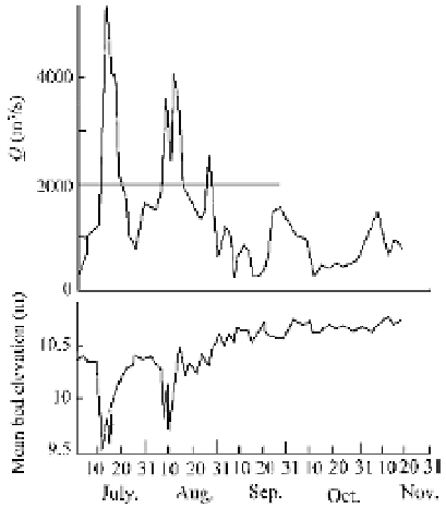
/s (Qi, 1993). Figure 6.23 shows the average bed elevation at the Lijin
Station corresponding to the discharge from July to November of 1977 (Yin and Chen, 1993). High
discharge causes deep erosion of the riverbed, whilst flood recession and low flow were accompanied by
aggradation.
Reservoirs have trapped a huge volume of sediment that resulted in a quick reduction in the sediment
load to the lower reaches. The reservoirs also reduced water flow to the lower reaches, clipping peak
flood discharges. Sediment carrying capacity of flow is proportional to the power of the discharge.
Sediment used to deposit in the lower river channel in dry years and was scoured away in wet years when
high discharge occurred. Reservoir regulation deprived the opportunities for bed scour and the channel
accumulatively silted up.
Development of the economy and growth of the population lead to the reclamation of the river
floodplain. Nowadays more than 1.7 million people are living on and plowing 270,000 ha farmland in
the lower Yellow River floodplain within the Grand Levees. The people built levees by the main channel
and prevented the floodplain from flooding, therefore, sediment mainly deposited in the main channel. In
the 1950s, 80-100% of the deposited sediment was on the floodplain, whereas in the 1990s 74-113% of
the sediment deposited in the main channel. Although the total amount of the annual sediment deposited
in the lower Yellow River was less, the amount of sediment deposited in the main channel was much
more than before, consequently, the channel shrank and the water conveying capacity of the river channel
reduced greatly. Figure 6.24 shows the variation of the water discharge capacity of the river channel
below elevation 93.5 m at Huayuankou in the period from 1958 to 1999. The capacity was about 18, 000
m
3
/s in 1960 and is now less than one tenth of that. In many sections the channel is silted up to an
elevation higher than the floodplain and is therefore named the “perched channel” within the “suspended
river”.
Fig. 6.23
Variation of bed elevation and the flood discharge at the Lijin Station during the flood season in 1977

Search WWH ::

Custom Search