Environmental Engineering Reference
In-Depth Information
Fig. 6.24
Reduction of the discharge capacity of the Yellow River Channel below elevation 93.5 m at Huayuankou
in the period from 1958 to 1999
6.4.2 Reclamation of the Floodplain Increases Flood Loss
Due to the high rate of population growth and the lack of land people reclaim the floodplain in the lower
Yellow River valley. There are about 1.7 million people dwelling on the floodplain within the Grand
Levees in the Henan and Shandong reaches of the river. They built levees within the river to protect their
hometowns on the floodplain although the floodplain was used for retention of rare floods. They are not
protected by the Grand Levees and exposed to high risk of flooding. When the inhabitants of a town near
the Yellow River Changdong Bridge were woken by a muffled roaring sound August 5, 1996, some part
of the town were already a meter under water. A flood of discharge 7,860 m
3
/s washed through lower
reaches of the river breaking levees and destroying 2,898 villages and 212 towns. About 2.41 million
people were affected by the flood and $800 million were lost. The flood discharge was much less than
the those of 1958 (22,300 m
3
/s) and 1982 (15,000 m
3
/s), but the flood caused the highest stage in
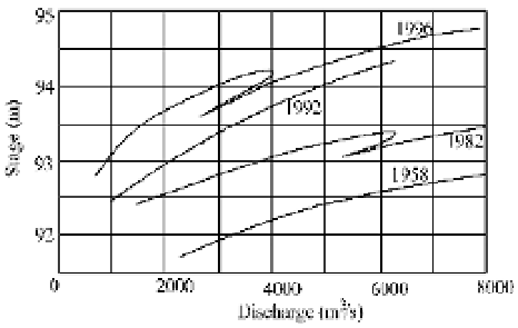
historical records. Figure 6.25 shows the stage-discharge relations of the 1996 flood and those of 1958
and 1982 (Zhao and Liu, 1997). The recurrence period of the flood with peak discharge about 8,000 m
3
/s
is only 2 years according to 1950-1996 data. In other words 8,000 m
3
/s or higher discharge occurred
once per 2 years but such heavy loss never resulted prior to 1990.
Fig. 6.25
Stage-Discharge relationships of 1996, 1992, 1982 and 1958 floods (after Zhao and Liu, 1997)
The high stage of the 1996 flood was due to the siltation of the main channel. Long term river evolution
data demonstrate that sedimentation occurs at low discharge and the river bed is scoured if the discharge
is over 1,800 m
3
/s. With flow regulation by the reservoirs, trapping of water and sediment by thousands
of warping reservoirs in the Loess Plateau, and diversion of huge amounts of water from the river, the
peak discharge of floods was cut off and the total runoff of floods was remarkably reduced. It was
estimated that if the 1996 rainstorm had occurred in 1950-1960, the peak discharge at Huayuankou would
have been over 12,400 m
3
/s (Zhao and Liu, 1997). Because the river channel now is rarely scoured by


Search WWH ::

Custom Search