Travel Reference
In-Depth Information
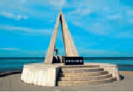
The stone marker at top marks Japan's northern-most point at Wakkanai on Hokkaidōs Cape Sōya. The
one above, at Yonagunijima's Cape Iri, marks Japan's southwesternmost point.
By air, as the crow lies, Yonaguni lies some 320 miles (515 kilometers) from Naha, 675
(1,090 kilometers) from Kagoshima on the Japanese mainland, 1,260 (2,030 kilometers) from
Tokyo and 1,660 (2,667 kilometers) from Sapporo. At its very closest points, Yonaguni Island
is only about 70 miles (112 kilometers) from the northeast coast of Taiwan and 65 miles (104
kilometers) due east of Ishigaki. It is a rugged, rocky island, shaped as a long oval, lying on
its side. It measures 7 miles (12 kilometers) across from its eastern tip at Cape Agari (
東崎
;
Agarizaki), to its western tip at Cape Iri. From north to south, it measures about 2.5 miles (4
kilometers) for most of its length, but narrowing at both ends. It has a surface area of just un-
der 11 square miles (29 square kilometers) and a circumference of 17 miles (27 kilometers).
Most of the island is surrounded by high cliffs and much of its shoreline is rock, although
there are a few beaches sprinkled here and there. Only about one-third of the island is level
enough for sugar cane growing or other agriculture. The rest is too mountainous or rocky.
The majority of Yonaguni's population of about 1,615 people reside in three main villages.
Yonaguni Town, which is called Sonai (
祖内
), in the center north, is by far the largest. The
town's grown around the fishing port and the airport is immediately to the west. There are
about a dozen
minshuku
in Sonai and one small luxury hotel just out of town. It's called the
Ailand Resort (
アイラン ドリゾート
; Aiundo-rezōto) and it has a fine restaurant, pool and
spa facilities.