Travel Reference
In-Depth Information
5
IKEIJIMA
伊計島
If we had a ship, we'd set sail south and then a bit west from Cape Henoko and its two little
islands to our next destination. By sea it's a little less than9 miles (14 kilometers) to Ikeijima,
the first and most northerly of a small group of islands. But we don't have a boat, so we'll
drive, staying on Okinawa's eastside coastal road, Route 329, for the most part. By this route
it's southwest counter-clockwise all the way around Kinbu Bay (
金武湾
; Kinbu-wan or Kin-
wan), then southeast down almost to the end of the Katsuren Peninsula (
勝連半島
; Katsuren-
hantō), then east over the almost 3-mile (5-kilometer)-long Kaichu-doro Causeway (
海中道
路
; lit. “Sea Center Road” or, more figuratively, “Road through the Sea”) to Henzajima, con-
tinuing northeast and across another bridge to Miyagijima, then north and across another
bridge to Ikeijima and its final tip—a true “Land's End.” Altogether, the route by road from
Cape Henoko at Camp Schwab to the end of Ikeijima (
伊計 島
; Ikéi-jima) is 40 miles (60
kilometers).
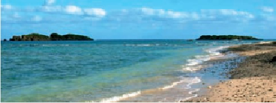
Uninhabited Nagashima (
“
Long Island”) at left and Tairajima (
“
Flat Island”) at right lie directly across
the mouth of Oura Bay, just of Cape Heneko.
Ikeijiima's Big Time Resort.