Geoscience Reference
In-Depth Information
4.3 20-22 October 2008 MCS Cevenol precipitation event
The last example consists in an isolated MCS (Fig. 13a) that developed along the south-
eastern flank of the Massif Central Mountains on October 20
th
and remained stationary for
about 15 hours. Again, this storm did not generate any significant damage, but it locally
produced rainfall accumulation in excess of 250 mm in a just a few hours.
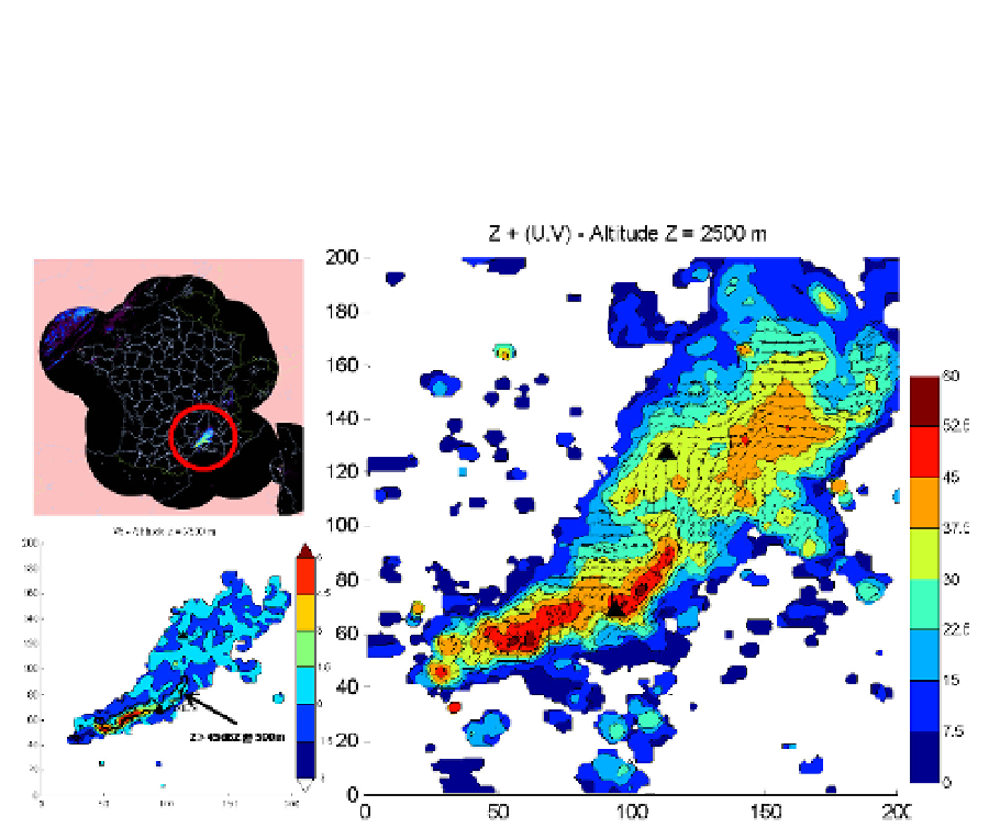
Fig. 13. Stationary mesoscale convective system observed on 20 October 2008 at 14 UTC.
(Left, top): French operational radar reflectivity mosaic output. (Right): Horizontal wind
vectors superimposed on radar reflectivity (shaded) at 2.5 km MSL within the 200 km x 200
km experimental domain, as derived from multiple-Doppler analysis of radar data. (Left,
bottom): Associated retrieved vertical velocity. Triangles show the location of Nimes and
Bollène radars. One every sixth vector is plotted.
The retrieved wind and reflectivity fields associated with this MCS at 14 UTC are shown in
Fig. 13b within a domain of 200 x 200 km centered between the Nimes and Bollene radars
(black triangles) at a horizontal resolution of 1 km. Note that only 4 radars (Bollene, Nimes,
Montclar and Collobrieres, see Fig. 1) are used in this analysis. This setup will be used to
produce high resolution wind fields in real-time during the first phase of the HyMeX
program in fall 2012. Radar-derived wind and reflectivity fields will be used to guide both
research aircraft and ground-based mobile radars systems towards the most interesting
areas. Overall, the radar analysis shows a rather complex wind circulation resulting from
the interactions between the incident flow originating from the Mediterranean Sea and the
terrain. A region of strong convergence was observed near Nimes due to the interactions of
westerly flow in the southern part of the massif with southerly-to-southwesterly flow to the
east. As a consequence, strong convection could be observed in this region while more