Geoscience Reference
In-Depth Information
12
(a)
12
(b)
11
11
10
10
9
9
8
8
7
7
6
6
5
5
4
4
3
3
50-55
2
2
45-50
40-45
1
1
35-40
0
0
30-35
200
400
600
800
1000
200
400
600
800
1000
(km)
(km)
25-30
20-25
12
12
(c)
(d)
15-20
11
11
10-15
10
10
5-10
0-5
9
9
8
8
7
7
6
6
5
5
4
4
3
3
2
2
1
1
0
0
800
1000
200
400
600
800
1000
200
400
600
(km)
(km)
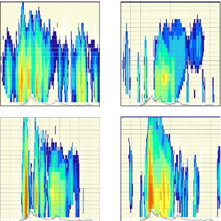
Fig. 12. Vertical cross-section of radar reflectivity (dBZ) at x=700 km (Fig. 10) at (a) 00 UTC,
(b) 6 UTC, (c) 12 UTC and (d) 18 UTC on 7 Sept 2010.
Wind observations would nevertheless have been quite useful to anticipate the behavior of
convective cells, especially in the Rhone valley where the intensity of the convection seemed
directly related to the direction and strength of the wind. On the other hand, the benefit
inferred from such products for research purposes is priceless. These wind fields could be
used to develop new methods for model verification as well as more efficient nowcasting
tools. Radar-derived wind information produced in a fully operational framework (i.e., in
real time and automatically) could also be relied upon to evaluate numerical model output
in real time (through identifying possible temporal or spatial phase shift in model output),
as well as to build a weather database that would be used for statistical analysis purposes or
more traditional case studies. Such capabilities, for instance, are at the heart of the upcoming
HyMeX field phase, which will be held in Sept-Nov 2012.