Geoscience Reference
In-Depth Information
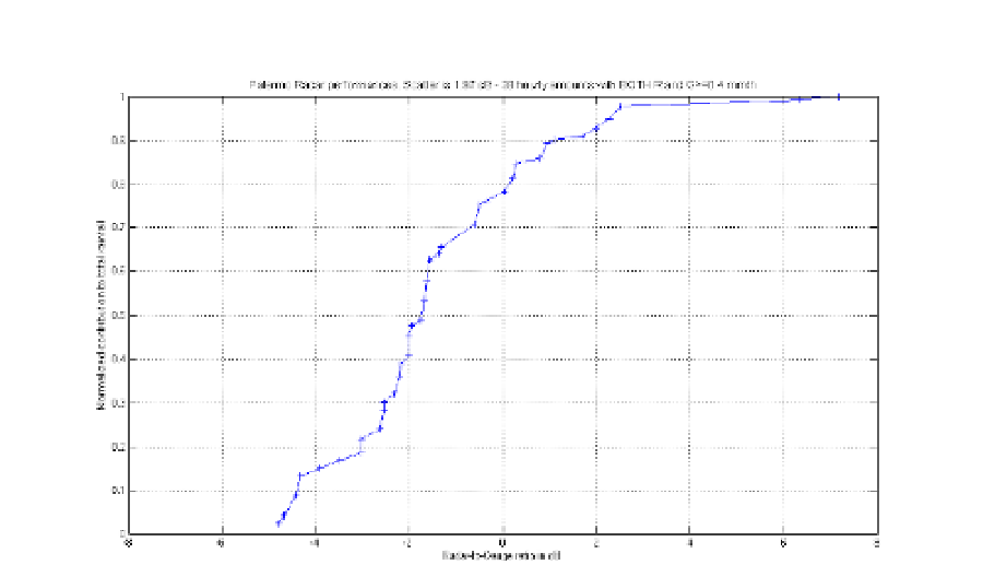
Fig. 9. Cumulative contribution to total rainfall as a function of Radar-Gauge ratio for hourly
precipitation with both R and G 0.4 mm/h (38 samples).
4.3 Quantitative precipitation estimation for the Bisacquino radar
The Bisacquino radar is located in the central-western part of Sicily: latitude is 37°.707;
longitude is 13°.262; altitude is 780 m above Mean Sea Level (MSL). As for the Palermo
radar (Sec. 4.2), it has been installed in autumn 2010.
For the quantitative evaluation of the radar estimates there is an optimal rain gauge run by
the Servizio Informativo Agrometeorologico Siciliano (SIAS) and installed in the
municipality of Giuliana (località Castellana). Its location (red triangle) with respect to the
radar (blue triangle) is shown in Fig. 10 together with the DEM of the area.
The radar-gauge distance is 8.7 km; the rain gauge altitude is 250 m above MSL. As can be
seen from Fig. 11, the gauge location is optimal not only in terms of range, but most of all in
terms of radar visibility: no partial beam shielding by relieves affects the mini radar 3.6°
Half Power Beam Width (HPBW), which is delimited by the two blue lines in Fig. 11 (the
radar beam axis has an angle of elevation set to 1°).
Furthermore, the hill located at 3 km range from the radar, causes partial beam shielding of
the remaining part of the primary lobe and total shielding of the secondary lobes in
elevation; consequently, we can conclude that residual ground clutter contamination
affecting radar echoes above the Giuliana rain gauge is negligible.
For what concerns QPE, 4 rainy days (96 hours) during the first 5 months of 2011 have been
analyzed; these days are February 23, March 13, April 26 and May 22. During these 96 hours
the Gauge (Radar) total amounts was 98.2 (77.7) mm, which corresponds to an “overall Bias”
of 1.0 dB (radar underestimation).