Geoscience Reference
In-Depth Information
5.4.3 Use of Doppler radar derived winds
Potentially, weather radar provides a high resolution source of wind observations via the
Doppler returns from hydro-meteors and insects. Currently, four weather radars in the
south of England produce Doppler radial winds operationally every 5 minutes when there
is precipitation (see Figure 7). The radars each perform scans at 5 elevations. The majority
are at 1, 2, 4, 6 and 9 degrees, although one radar near London scans at 1, 2, 4, 5 and 5.5
degree elevations. Doppler winds are available to a range of about 100 km. This provides
a small amount of dual or triple Doppler overlap in southern England as can be seen in
Figure 7.
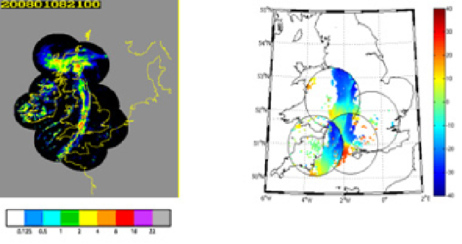
Fig. 7. A comparison of UK weather radar network coverage (left) and Doppler radar radial
wind coverage (right) as of 8 January 2008. The key shown bottom-left represents
precipitation rate in units of mm/hour. Note that dry areas in the left-hand graphic are
represented by the colour black. The grey shading indicates areas without UK weather radar
coverage.
Code has been developed to allow their processing, quality control, monitoring, super-
obbing and data assimilation. Super-obbing is the process of combining observations that
are of higher resolution than the forecast or analysis grid to reduce the data volume
(Lorenc, 1981) and representativeness errors. Trials have been run to investigate the impact
of Doppler radar radial winds on UK4 model forecasts using 3D-Var. The use of Doppler
radial wind scans valid at analysis time was made operational in the UK configurations of
the Unified Model in 2011. Three-hourly radial winds now replace hourly VAD winds from
the same radars in the three-hourly 3D-Var cycles.
Much work has been done on specification of observation errors and investigating the
impact of super-ob variances, errors derived from observation-background variances and
errors derived from the Hollinsgworth and Lonnberg technique (Hollingsworth &
Lonnberg, 1986).
The impact of Doppler radar radial wind data has been assessed over southern England
using a prototype nowcasting system with a 1.5 km grid length model and hourly cycling
1.5 km 3D-VAR. For the initial tests, only the radar scans closest to the analysis hour were
selected from each radar for assimilation. Initial subjective and objective verification looks